

Landslide hazard assessment
The most accepted definition of landslide hazard requires the definition of the probability, the time or frequency of occurrence, and an indication of the level of threat a landslide may pose. The first digital document we can find where the prediction of landslide occurrences is addressed dates back to 1972. At that time, geomorphologists mapped and labelled the landscape according to their experience to recognize slopes prone to fail.
Much has changed since then. The geomorphological community focused on estimating landslide occurrences has now embraced data-driven models to generate reliable predictions and support master planning. For fifty years, these data-driven models have consisted of binary classifiers, aimed at assessing where landslides are likely to manifest across a given landscape, leaving unexplored the component that pertains to the level of threat.
To fill the gap between current data-driven models for landslide prediction and landslide hazard, we introduce the first statistically-based model able to estimate how large a landslide or multiple landslides together may be within a specific areal unit. The model is fitted to the most complete global dataset of landslides induced by earthquakes and is able to provide accurate information about the extent of the failed surface across a given landscape (Lombardo et al., 2021).
To extend on the above work, we propose a new paradigm where the landslide area is modelled together with the probability of landslide occurrence. This model represents the first attempt to simultaneously address two out of the three requirements of the landslide hazard definition. This is an unprecedented achievement, and it also represents an uncharted territory as it offers an alternative to standard protocols used by decision-makers to minimize the risk of landslides to which mountain communities are exposed (Bryce et al, 2022).
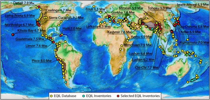
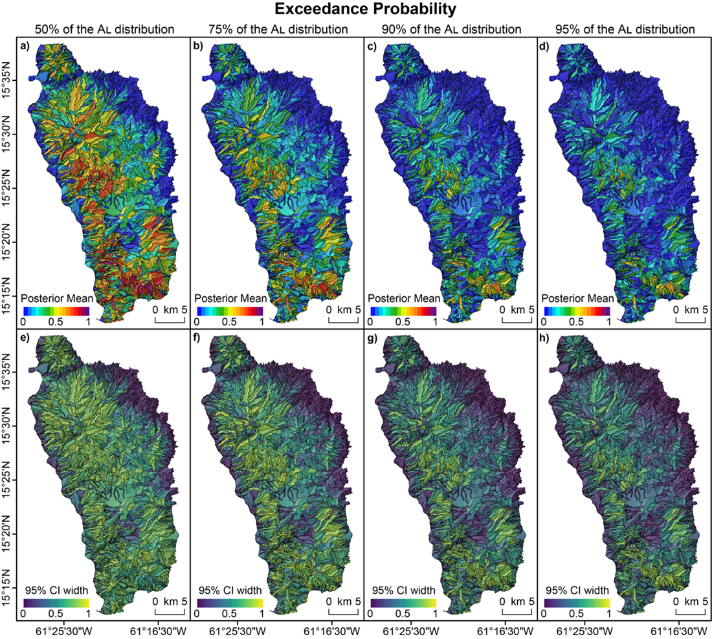
Top: Map showing locations (yellow dots) of all the earthquakes known to have triggered landslides (Lombardo et al., 2021). Middle and bottom: Maps displaying the unified landslide hazard assessment proposed in Bryce et al., 2022. Specifically, they show exceedance probability estimates (top) and a measure of their uncertainty (bottom) for landslide sizes above the 50%, 75%, 90% and 95% empirical quantiles. The computations were based on NxM = 5x10⁵ predictive posterior samples of the Gaussian and Bernoulli models.

Researchers
Publications