

Verbiest Map
 KUNYU QUANTU 坤輿全圖 (A Map of the Whole World), by Ferdinand Verbiest, 1674, showing the two hemispheres of the world was designed for the Chinese Emperor Kangxi (1662-1722) by the Jesuit Father Ferdinand Verbiest (1623-88), in 1674. Verbiest was one of a handful of Jesuits who were employed at the Chinese court during the 17th-18th century and who introduced ideas of Western science to China. Printed from woodblocks, the map was part of a larger geographical work called Kunyu tushuo (Illustrated Discussion of the Geography of the World), which included information on different lands as well as the physical map itself.
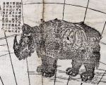
Cartouches provide information on the size, climate, land-forms, customs and history of various parts of the world and details of natural phenomena such as eclipses and earthquakes. Columbus’ discovery of America is also discussed. Images of ships, real and imaginary animals and sea creatures pepper both hemispheres, creating a visually stunning as well as historically important object.
The map is very rare. In Britain, only the British Library has another copy. The one displayed here came to Europe in 1734 and entered William Hunter's collection between 1765 and 1779. It is one of the earliest known examples to reach Europe directly from Beijing. Although it had been on display in the Hunterian Museum in the past, it was kept in storage for many years until its importance was recognised by Professor Nick Pearce, Head of the School of Culture and Creative Arts at the University of Glasgow and an expert in Chinese art studies and the history of collectors and collecting in China. It is now on display in The Hunterian Museum.