Dr Rachel Opitz
- Affiliate (Archaeology)
Research interests
- Archaeological Remote Sensing
- Landscape Archaeology
- Mediterranean Archaeology
- Iron Age and Roman Italy
- Digital methods and publication
- 3D modeling, analysis and interfaces
- Interdisciplinary Data Integration
- Archaeology and Precision Agriculture
Key Field and Research Projects
- ipaast-czo: interoperable precision agricultural and archaeological sensing technologies
- The Gabii Project: studying and excavating an ancient Latin city
- The dataARC Project: Enabling Research on the Long-Term Human Ecodynamics of the North Atlantic
Completed Projects:
- The im/material network (with Gareth Beale)
- CALCRome: Studying Use Wear through Digital Ceramics
- SPARC: SPatial Archaeometry Research Collaborations
Network
- ArchaeoLandscapes International - an international network focused on landscape archaeology
- CAA International - the international society for Computer Applications & Quantitative Methods in Archaeology
- PROSPECT - an international network focused on research and education in archaeological prospection
-
I co-lead the Immersive Experiences ArtsLab, a community at the University of Glasgow, made up of researchers, artists, professionals and students interested in work at the intersection of arts and humanities, virtual and augmented reality, and related technologies.
https://www.gla.ac.uk/researchinstitutes/artslab/labsandthemes/ourlabs/immersiveexperiences/
Grants

ipaast-czo: interoperable precision agricultural and archaeological sensing technologies
Agricultural landscapes sit at the intersection between nature, humanity, and technology. Today, rural agricultural landscapes are being fundamentally transformed by the introduction of advanced farming technologies in the form of precision agriculture and by the deployment of new policies and incentives to address the climate crisis, environmental sustainability and food security. This project aims to study rural agricultural landscapes as complex entities rooted in long-term human-environment interactions and shaped by contemporary farming practices in order to engage with this transformation.
This foundational work will be accomplished through this project’s workshop and field trial activities, through which an interdisciplinary team will collaborate to develop interoperable data descriptions and workflows for remote and near-surface sensing data used by archaeologists and precision-agriculturalists to study these landscapes. Designing truly compatible data standards and analytical routines requires delving deeply into implicit disciplinary ontologies and epistemologies, because we operationalize our perspectives and agendas through the design of our data structures and workflows. This design work will elucidate these implicit properties and open a discourse around the complex intersecting interests and priorities of stakeholders in rural communities and places, setting an agenda for a new, shared approach to our changing agricultural landscapes.
This project is led by a team from the Universities of Glasgow, Ghent, Siena, Florence and Spain’s Consejo Superior de Investigaciones Científicas (CSIC).
Learn more at https://ipaast-czo.glasgow.ac.uk/.
![]()

dataArc, Building Cyberinfrastructure to Enable Interdisciplinary Research on the Long-Term Human Ecodynamics of the North Atlantic, is a NSF funded project building the cyberinfrastructure necessary to support research on human ecodynamics in the North Atlantic. This research requires the analysis of diverse and heterogeneous datasets, the cooperation of international research teams, and the deep time perspective provided by archaeology. Data discovery, integration, and visualization are critical to all aspects of this research, and the development of cyberinfrastructure (CI) and tools can enable this crucial collaborative research. Investing in comprehensive online cyberinfrastructure provides the opportunity to link collaborators and data from the natural sciences, social sciences, and the humanities, resulting in the opportunity for a holistic approach to understand the rapid social and environmental changes that occurred in the past and for the creation of digital tools for expanded capacity to engage other users, including students and Indigenous northern communities.
Project Lead and co-PI.
Learn more at: https://www.data-arc.org/
The Gabii Project is an international archaeological initiative. It was launched in 2007 with the objective of studying and excavating the ancient Latin city of Gabii, a city-state that was both a neighbor of, and a rival to, Rome in the first millennium BC.
Director of Topography and Digital Data.
Learn more at: https://sites.lsa.umich.edu/gabiiproject/
Past Grants
![]()
SPatial Archaeometry Research Collaborations (SPARC). SPARC is an NSF-funded program at the Center for Advanced Spatial Technologies (CAST) and Archeo-Imaging Lab (AIL) dedicated to promoting geospatial research in archaeology. SPARC offers direct support to archaeological projects through awards in three categories:
- Fieldwork: On-site data collection
- Data & Analytics: Preparation, processing and analysis of geospatial data
- Publication: Presentation, publication and archiving of complex geospatial datasets
co-PI.
Learn more at: https://sparc.cast.uark.edu/
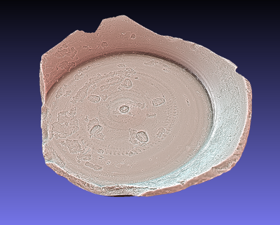
CALCRome, the Capturing the Life Cycle of Ceramics in Rome Project, saw a collaboration with archaeologists Marcello Mogetta at the University of Missouri and Laura Banducci at Carleton University to investigate traces of past use seen on Black Gloss ceramics from funerary and ritual contexts. Black gloss pottery plays an important role in our understanding of the consumption of food and drink both every day and on special occasions. Where did they come from, and how were they chosen for to be placed into the tomb of a friend or family member, or left in a sanctuary as an offering? To address these questions, our team carried out 3D scanning to capture detailed surface models of the objects in 2016 and 2018. These models were analysed to assess the types and extent of wear and marks of use on their interior and exterior surfaces. Research focused on developing new ways to measure and quantify these different types of wear, so that analyses can be performed across large datasets and more consistent assessment of the extent and type of use- wear can be made.
Co-PI.
Supervision
I am happy to supervise Masters and Doctoral dissertations on topics related to archaeological remote sensing, landscape archaeology, computational and digital methods in archaeology, and applications and implications of 3D data in archaeology. My regional and chronological expertise lies in the Iron Age and Roman Mediterranean.
Teaching
Courses
- 20 Things that changed the World (Level 2)
- Reflective Archaeological Practice (Level 3 / Honours)
- GIS in Archaeology (Level 3 / Honours / Masters)
- Remote Sensing for Archaeology and Human Ecology (Honours / Masters)
- Archaeological Digital Imaging (Honours / Masters)
Programme Convenor for the Archaeology PGT programmes
https://www.gla.ac.uk/postgraduate/taught/archaeology/