

Catchment susceptibility to hydrometeorological events: sediment flux and geomorphic change as drivers of flood risk in the Philippines
Published: 17 May 2021
In the Philippines, rivers are particularly dynamic; risks arising from sedimentation and erosion need to be assessed and incorporated into flood risk management to mitigate the impact of flooding on welfare and the economy.
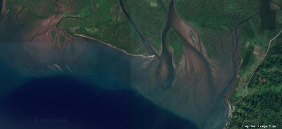
River morphology results from sediment transport and sedimentation, which are both a consequence of water flow. Episodic variation in natural (e.g. typhoons, earthquakes, volcanoes) and anthropogenic (e.g. gravel mining, river bank protection) sediment supply drives changes in riverbed levels and sedimentology. These changes determine channel capacity and flow routing, and thus associated flood risk to people and property. The same factors determine variations in lateral bank erosion rates; elevated rates result in the loss of developed floodplain and the failure of critical infrastructure such as road bridges. Despite the significance of variation in riverbed levels and channel position for flood risk, geomorphological processes are commonly overlooked in flood risk mapping. In the Philippines, rivers are particularly dynamic; risks arising from sedimentation and erosion need to be assessed and incorporated into flood risk management to mitigate the impact of flooding on welfare and the economy.
This project aims to:
This project aims to:
(i) develop a national-scale catchment characteristics database, and associated river geometry relations, to assess the susceptibility of different catchments to morphological change impacts on flood hazard; and
(ii) assess flood hazards arising from morphological change associated with variations in sediment supply and the influence of lateral constraints on channel morphological adjustment.
To achieve the first aim we will use national scale topographic models and repeat satellite imagery to assess fluvial and landscape characteristics to identify indicators of enhanced channel mobility and sediment transport, with outputs available from a river centreline Geographic Information System with data points every 1 km along the Philippines river network. This national scale dataset will be used by project partners to assess and plan infrastructure developments. To achieve the second aim we will generate repeat, high-resolution Digital Elevation Models (DEMs) of the Pinacanauan de Ilagan River and the Bacarra Rivers, from airborne Light Detection and Ranging (LiDAR) and bathymetric surveys. We will difference these DEMs to map patterns of erosion and deposition during a wet season, and calculate a sediment budget for each river. The DEMs and sediment budget will then be used to parameterise and assess hydro- and morpho-dynamic models that will be used to investigate changes in flood risk due to morphological change. This framework will be used, by project partners, to guide river and flood management in the Pinacanauan de Ilagan and the Bacarra catchments. The framework will also be transferable to other rivers in the Philippines, and farther afield in SE Asia and beyond.
This proposal forges a partnership between the University of the Philippines (UP) Diliman, the University of Glasgow, four Filipino project partners, and project partner Prof Brierley (University of Auckland). Specifically, the Philippine project partners are: the Mines and Geosciences Bureau; the Department of Public Works and Highways; and two Local Government Units in the study catchments, namely City of Ilagan and Municipality of Vintar. The project brings together UP Diliman's expertise in geomatics with the University of Glasgow's expertise in fluvial geomorphology and numerical modelling, to undertake research that will shed light on the morphodynamics of tropical rivers and produce tools that will be used for sustainable fluvial flood management in the Philippines.
This proposal forges a partnership between the University of the Philippines (UP) Diliman, the University of Glasgow, four Filipino project partners, and project partner Prof Brierley (University of Auckland). Specifically, the Philippine project partners are: the Mines and Geosciences Bureau; the Department of Public Works and Highways; and two Local Government Units in the study catchments, namely City of Ilagan and Municipality of Vintar. The project brings together UP Diliman's expertise in geomatics with the University of Glasgow's expertise in fluvial geomorphology and numerical modelling, to undertake research that will shed light on the morphodynamics of tropical rivers and produce tools that will be used for sustainable fluvial flood management in the Philippines.
Planned Impact
The impact goal of this project is to deliver novel, evidence-based solutions to flood risk management that will enhance welfare and economic growth, and support the development of geomorphological expertise in research centres and government agencies in the Philippines, ultimately benefiting citizens in the most vulnerable areas. It is expected that this project will provide evidence that can be used to inform a case for investment in flood hazard assessment and river management so as to minimise economic and social costs associated with future hazards arising from morphological change. At present, comprehensive catchment-scale geomorphological analyses are not being undertaken to examine the susceptibility of rivers to morphological change, which has resulted in catastrophic failure of bridges and loss of property to lateral erosion. A national-scale catchment characteristics database and a review of hydraulic geometry relations used in engineering practice will provide a foundation for more comprehensive incorporation of morphological change into river management and thus reduce flood hazards. The project team will work with policy makers, government organisations, practitioners and communities to identify the main challenges and interventions that can be used to inform appropriate management activities. During the project, the team have direct access to these stakeholders.
Knowledge exchange activities will include River Styles, Geomorphic Change Detection and flood risk workshops, local focus groups, and a dynamic rivers symposium. These activities will ensure that research findings are used by Philippine beneficiaries to reduce flood risk in the catchment study areas and guide fluvial geomorphological assessments at a national level.
Knowledge exchange activities will include River Styles, Geomorphic Change Detection and flood risk workshops, local focus groups, and a dynamic rivers symposium. These activities will ensure that research findings are used by Philippine beneficiaries to reduce flood risk in the catchment study areas and guide fluvial geomorphological assessments at a national level.
First published: 17 May 2021
UofG - School of Geographical and Earth Sciences
Partner Organisations