

Travel to Garscube Campus
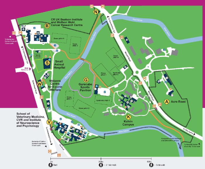
Garscube campus is 3 miles from the main campus and home to
- Garscube Sports Complex
- Wolfson Hall and Kelvin Conference Centre
- the Small Animal Hospital
- the Weipers Centre for Equine Welfare
- the Scottish Centre for Production Animal Health and Food Safety
- the Beatson Institute for Cancer Research and Wolfson Wohl Cancer Research Centre
MVLS also have a significant research presence on Garscube campus.
Access to the Campus
Access to the campus
There are two main vehicular accesses to the campus, one from Maryhill Road and one from Switchback Road. There are additional pedestrian and cycling entrances from both roads. The facilities and buildings on the campus can be accessed from both roads, but a 10 minute walk over the Lady Campbell Bridge to the other side of the river Kelvin may be needed. If using a navigation app/Sat Nav please use G61 1BD as the postcode; this will take you directly to the Campus Gatehouse where staff will be able to direct you to the relevant building.
Cycling and Walking
Cycling and Walking
There are excellent walking and cycling routes on the campus and a direct cycling route between Gilmorehill campus and Garscube along the river Kelvin. They are shown on the Garscube campus map. For an enlarged version of this map with building key click Garscube Active Travel Map.
A complete list of all Garscube bicycle parking can be found here, and a list of showers here.
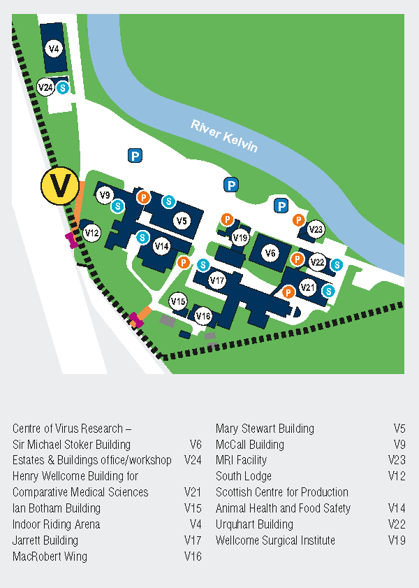
The map below shows the locations of bicycle parking ('P') and showers ('S') at the Veterinary School buildings.
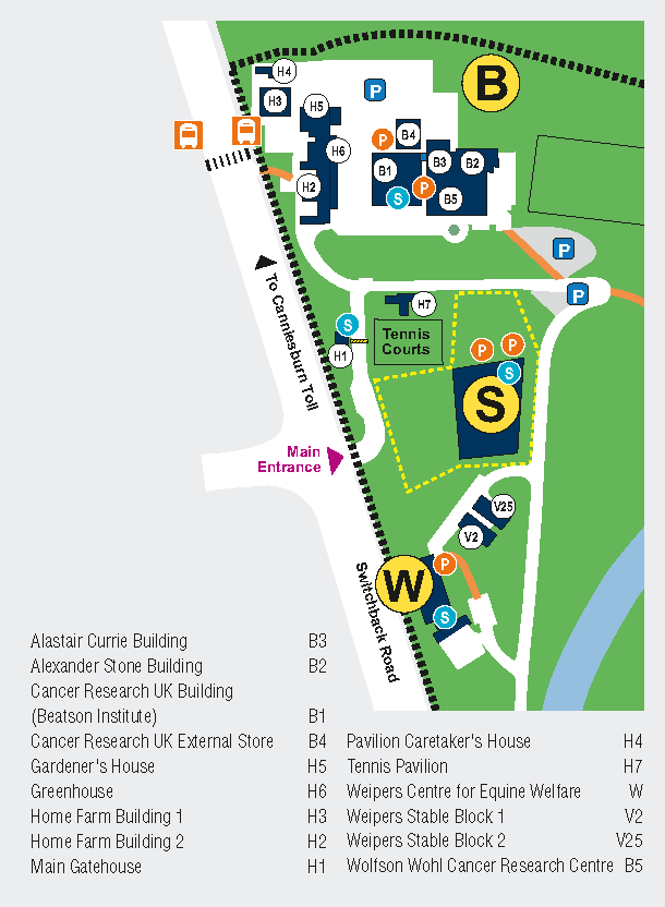
The map below shows the locations for bicycle parking ('P') and showers ('S') at the Beatson and Wolfson Wohl Cancer Research Institutes.
University staff and students can use free memberships for nextbike for their hire bikes. The University continues negotiations with nextbike to install bicycle hire stations at Garscube.
Public Transport - Commuting to Garscube Campus
By train
Scotrail 'Low Level' train from between City Centre and Milngavie to Westerton or Anniesland station.
For Veterinary School
| Walk 16 minutes from Westerton Station to the Ilay Road campus entrance | |
|
Walk 20 minutes from Anniesland Station to the Ilay Road entrance |
Directions |
For Cancer Research Institutes
| Walk 10 minutes from Westerton station to the Home Farm campus entrance for Cancer Research Institutes | Directions |
By bus
along Switchback Road
| CityBus Service 15 | From and to Milngavie Station to City Centre, via Switchback Road, Gartnavel Hospitals, University Avenue and Charing Cross | hourly service | Timetable | ||
| FirstBus M4 | Partick bus station, via Byres Road/Highburgh Road/Hyndland Road to Anniesland, Sutcliffe Street on Bearsden Road | hourly service or less | Timetable | Map | Walk from Anniesland to Garscube Campus entrance required (13 min) |
| Glasgow Citybus 118 | part route from and to Gartnavel Hospital, evening service (starting after 18:00) | hourly service | Timetable | Map |
along Maryhill Road
| FirstBus 60/60A | Easterhouse, Shettleston to City Centre, then Drumchapel via Maryhill Road | every 10 minutes, less in the evening | Timetable |
| CityBus 17 | Duntocher to City Centre, via Bearsden and Maryhill | every 15 minutes | Timetable |
|
First Bus 8 |
Partick to Parkhead, via Byres Road, Queen Margaret Drive, Maryhill Road and Springburn | half-hourly service, less in the evening | Timetable |
|
First Scotland East X10/X10A |
(Killearn, Strathblane) Milngavie, Maryhill, City Centre via Great Western Road | hourly service | Timetable |
More Information
Public Transport - Intercampus Travel
Travel from ...
Fare and Ticket information
Related Links
- All First Bus timetables
- All CityBus timetables
- Traveline Scotland - journey planner tool
Information for Car Drivers
Information for car drivers
When driving on campus it is imperative that the 10 mph speed limit is always observed. Pedestrians have right of way at all times.
On-campus parking is allowed for permit holders. Please see the Car Parking webpages for parking regulations and information on permits.