Overview
The site of Kourion lies on the south coast of Cyprus, on and around a triangular plateau overlooking the sea to the south and the Akrotiri Peninsula to the south-east. It is 3 km west of the Kouris River, and exploited the alluvial land created by that river. 150 years of excavations have produced evidence for a thriving city lasting from the Late Geometric to the Late Roman periods, with prehistoric predecessors and Medieval successors to the east round the modern village of Episkopi.
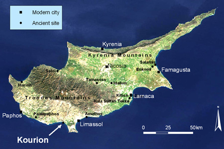
The Kourion Acropolis forms a long triangle with its sharp end pointing north-west and its shortest side facing south-east. The Amathous Gate lies in the centre of the south-eastern side, occupying the midpoint of a natural defile leading up into the Acropolis. The Amathous Gate Cemetery extends eastwards from the gate and runs round the eastern corner of the Acropolis at the foot of the cliff.
In the flat ground immediately below the Amathous Gate Cemetery lies the probably Byzantine church of Ayios Ermoyenis, itself surrounded by tombs of the Archaic to Roman period. There seem to be no tombs to the west of the Amathous Gate, thus restricting this cemetery to a very specific area below the Acropolis cliff.
The main road leaving ancient Kourion by the Amathous Gate almost certainly did not follow the line of the modern Kourion Theatre Road. This modern road was only made possible by a massive embankment which obscures the lower cliff. The ancient road ran directly south-east from the Amathous Gate, where a broad and regular ramp leads gently down from the gate to the fields below.
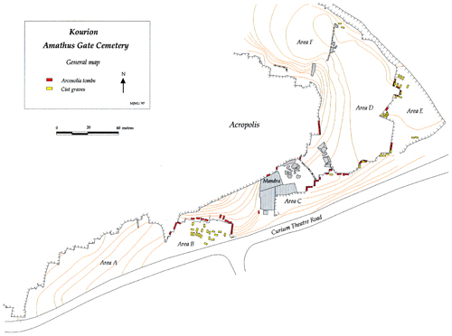
We divided the Amathous Gate Cemetery into seven distinct areas, termed Areas A–G. This whole area was mapped and its visible remains recorded (mainly cist tombs, quarrying and facetting, and chamber tombs). Area B was excavated entirely, along with a range of exploratory trenches in Area A and some individual cist tombs in Area E.
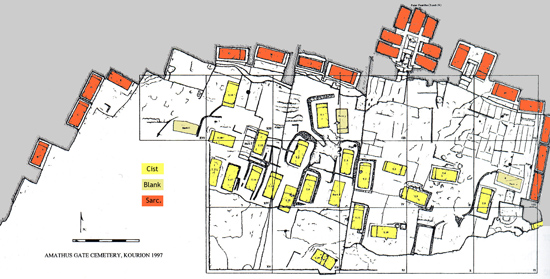
Plan of Area B (1997)
Aims
- to reconstruct the main phases of the Roman cemetery
- to investigate the development of mortuary customs, particularly the transition from pagan to Christian burial practices
- to investigate the biological relationships of the population buried in the tombs, both at a local and regional level, and to compare the patterns of pathology with contemporary populations elsewhere in Cyprus and the Mediterranean
- to investigate the funerary landscape of Kourion
- to investigate trade networks within Cyprus, and between Cyprus and the Eastern Mediterranean, by means of stylistic analysis and Neutron Activation Analysis of the pottery
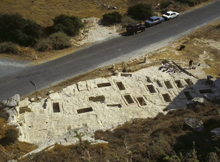
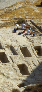
View of tombs in Area B from the edge of the Acropolis
Preliminary results
Excavation revealed seven main phases of interest (for more detail, see the Phases).
- Hellenistic material, much of it in secondary contexts, but including a large ashlar wall
- Chamber tombs (1st–3rd centuries AD), with extensive information about their construction, organisation, and post-interment ritual
- Dumping of ceramics and other material from the 1st-3rd centuries AD
- Quarrying and facetting of the cliffs (4th century AD)
- Cist tombs (late 4th–6th centuries AD), with a large and well-preserved assemblage of human remains and evidence for both Christian and pagan practices
- Lime kiln
The pottery assemblage from the site proved to be a major source of information for investigating the connections of Kourion with the rest of Cyprus and the Eastern Mediterranean. The fine wares and transport amphorae demonstrate trade relations both within the island and further afield. Our numismatic and stone assemblages provide supporting evidence to address issues of the broader connections of Kourion.
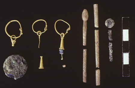
Burial assemblage from Tomb B21 cist grave
The human remains constitute an exceptionally well-preserved body of material, with c. 125 individuals studied. Pathologies include osteoarthritis, healed fractures, possible cribra orbitalia, and some developmental defects, though dental health is generally good. They allow excellent comparisons with populations from elsewhere in Cyprus, and from Crete and Carthage.
Our reconstruction of Kourion’s funerary landscape shows a very deliberate placing of chamber tombs along a dedicated ‘cemetery road’. Even after this road had been partially quarried away, individual sarcophagi of the old chamber tombs remained visible in the vertical rock faces left by the quarrying, and the subsequent cist tombs still referred to this road, placed so that they clustered along its route.
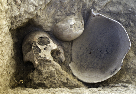
Skull and cooking pot in situ (Tomb B15)
The combination of material culture and human remains within a funerary and urban landscape provide an opportunity for an extensive study of life at Roman Kourion. This ranges from an overview of the position of the city itself in Cyprus and the Eastern Mediterranean to the details of customs, daily life, and the well-being of its population.