

GOTREES (Govan Tree-community for ecosystem services)

Building a cost-effective approach for mapping trees and their related ecosystems services from the Govan ward to the city scale.
The Science of the GOTREES project
The city of Glasgow is home of approximately 580,000 trees providing a wide array of ecosystems services, from flood mitigation and carbon capture, to cleaning the air from pollutants and sustaining animal diversity. Understanding the diversity and distribution of trees across the city and the cost/benefits of city tree cover is essential for urban planning and sustainable climate actions to foster resilient communities that can adapt to climate change.
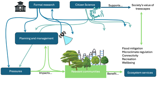
Figure 1. Systems approach diagram showing how formal research and citizen sciences in combination help better understand environmental pressures that impact policy and management, fostering the development of resilient communities, whilst supporting a better appreciation of treescapes and their associated ESS.
The project builds upon GALLANT’s community activities to identify trees in Govan by including tree species in the Govan ward and quantifying their ability to intercept rain and store carbon. This citizen-science derived data will be used to scale up the ability to monitor city trees through remote sensing and geospatial AI-empowered multimodal learning techniques and create a systems-based approach to enhance urban green spaces, informed by local communities' knowledge and needs.
It will be a first step towards a Glasgow-City-Council-wide map of trees and their associated ESS. The research will focus on Govan, developing methodologies that can be applied to the entire GCC area. It has the potential to provide a replicable methodology to monitor tree ecosystem services and inform city planning strategies, as well as onboarding local communities in tree management and voicing community-informed needs for planning and development.