Freya Muir
School of Geographical and Earth Sciences
University of Glasgow | G12 8QQ
LinkedIn | Google Scholar | GitHub | Dynamic Coast | OirthirSAT
![]() https://orcid.org/0000-0003-4702-2963
https://orcid.org/0000-0003-4702-2963
Research title: Real-time Monitoring and Modelling of Coastal Change
Research Summary
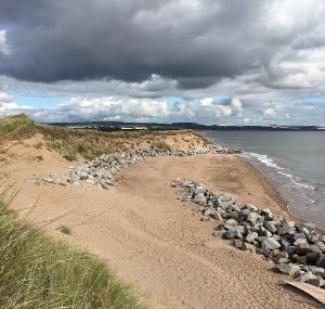
My ultimate research goal is to create a framework for predicting shoreline change in a range of coastal environments in response to short-term weather events. I hope to extract information about the coast and storm activity using automatic analysis of satellite and ground-based imagery, and weather and wave forecasts. These conditions will then feed into a numerical model of shoreline change, which will form the basis of a user-friendly, opensource software solution to predict a coastline's response to upcoming storms that can be run regularly at a range of spatial and temporal scales by coastal managers and stakeholders.
See the 1-minute summaries of my work below:
Publications
2024
Muir, Freya M.E.  ORCID: https://orcid.org/0000-0003-4702-2963, Hurst, Martin D. ORCID: https://orcid.org/0000-0002-9822-076X, Richardson-Foulger, Luke, Rennie, Alistair F. and Naylor, Larissa A. ORCID: https://orcid.org/0000-0002-4065-2674
(2024)
VedgeSat: an automated, open-source toolkit for coastal change monitoring using satellite-derived vegetation edges.
Earth Surface Processes and Landforms, 49(8),
pp. 2405-2423.
(doi: 10.1002/esp.5835)
ORCID: https://orcid.org/0000-0003-4702-2963, Hurst, Martin D. ORCID: https://orcid.org/0000-0002-9822-076X, Richardson-Foulger, Luke, Rennie, Alistair F. and Naylor, Larissa A. ORCID: https://orcid.org/0000-0002-4065-2674
(2024)
VedgeSat: an automated, open-source toolkit for coastal change monitoring using satellite-derived vegetation edges.
Earth Surface Processes and Landforms, 49(8),
pp. 2405-2423.
(doi: 10.1002/esp.5835)
2023
Muir, Freya ORCID: https://orcid.org/0000-0003-4702-2963 and Gibbs, Joe
(2023)
OirthirSAT: Keeping tabs on coastal change.
GeoConnexion,
Muir, Freya ORCID: https://orcid.org/0000-0003-4702-2963, Hurst, Martin ORCID: https://orcid.org/0000-0002-9822-076X, Richardson-Foulger, Luke, Rennie, Alistair and Naylor, Larissa ORCID: https://orcid.org/0000-0002-4065-2674
(2023)
Watching the Grass Grow: Delineating Coastal Vegetation Edges from Satellite Imagery.
2023 British Society for Geomorphology Annual Meeting, Edinburgh, UK, 4-6 Sept 2023.
(Unpublished)
2022
Horton, Bruce, Naylor, Larissa A. ORCID: https://orcid.org/0000-0002-4065-2674, Muir, Freya ORCID: https://orcid.org/0000-0003-4702-2963, Hansom, Jim D. ORCID: https://orcid.org/0000-0002-4443-2089, McCann, Matthew, Fraser, Michelle and Leach, Roisin
(2022)
Granton Coastal Park: a high-level climate adaptation and environmental cost benefit assessment.
Project Report.
Environmental Policy Consulting and University of Glasgow.
(doi: 10.36399/gla.pubs.275216).
2021
Dunkley, Ria ORCID: https://orcid.org/0000-0003-0238-7344, MacDonell, Craig ORCID: https://orcid.org/0000-0002-5516-5078, Naylor, Larissa A. ORCID: https://orcid.org/0000-0002-4065-2674, Muir, Freya M.E. ORCID: https://orcid.org/0000-0003-4702-2963, Fitton, James, Rennie, Alistair, Hansom, Jim ORCID: https://orcid.org/0000-0002-4443-2089 and Hurst, Martin ORCID: https://orcid.org/0000-0002-9822-076X
(2021)
Using Coastal Erosion Disadvantage Maps as a Climate Change and Strategic Urban Planning Tool for Scotland.
Built Environment and Net Zero – A COP26 Conference from the Centre for Sustainable Solutions, 11 Nov 2021.
Rennie, A.F., Hansom, J.D. ORCID: https://orcid.org/0000-0002-4443-2089, Hurst, M.D. ORCID: https://orcid.org/0000-0002-9822-076X, Muir, F.M.E. ORCID: https://orcid.org/0000-0003-4702-2963, Naylor, L.A. ORCID: https://orcid.org/0000-0002-4065-2674, Dunkley, R.A. ORCID: https://orcid.org/0000-0003-0238-7344 and MacDonell, C.J. ORCID: https://orcid.org/0000-0002-5516-5078
(2021)
Dynamic Coast Research Summary (2021).
Technical Report.
Centre of Expertise for Waters.
Rennie, A.F., Hansom, J.D. ORCID: https://orcid.org/0000-0002-4443-2089, Hurst, M.D. ORCID: https://orcid.org/0000-0002-9822-076X, Muir, F.M.E. ORCID: https://orcid.org/0000-0003-4702-2963, Naylor, L.A. ORCID: https://orcid.org/0000-0002-4065-2674, Dunkley, R.A. ORCID: https://orcid.org/0000-0003-0238-7344 and MacDonell, C.J. ORCID: https://orcid.org/0000-0002-5516-5078
(2021)
Dynamic Coast: The National Overview (2021). CRW2017_08.
Technical Report.
Scotland's Centre of Expertise for Waters (CREW).
Dunkley, R.A. ORCID: https://orcid.org/0000-0003-0238-7344, MacDonell, C.J. ORCID: https://orcid.org/0000-0002-5516-5078, Naylor, L.A. ORCID: https://orcid.org/0000-0002-4065-2674, Muir, F.M.E. ORCID: https://orcid.org/0000-0003-4702-2963 and Fitton, J.M.
(2021)
Dynamic Coast: Mapping Coastal Erosion Disadvantage in Scotland.
Technical Report.
Centre of Expertise for Waters.
Dunkley, R.A. ORCID: https://orcid.org/0000-0003-0238-7344, MacDonell, C.J. ORCID: https://orcid.org/0000-0002-5516-5078, Naylor, L.A. ORCID: https://orcid.org/0000-0002-4065-2674, Muir, F.M.E. ORCID: https://orcid.org/0000-0003-4702-2963 and Fitton, J.
(2021)
Dynamic Coast: Mapping Coastal Erosion Disadvantage in Scotland. CRW2017_08.
Technical Report.
Scotland's Centre of Expertise for Waters (CREW).
Fitton, J., Rennie, A.F., Hansom, J. ORCID: https://orcid.org/0000-0002-4443-2089 and Muir, F.M.E. ORCID: https://orcid.org/0000-0003-4702-2963
(2021)
Dynamic Coast: Coast X-Ray. CRW2017_08.
Technical Report.
Scotland's Centre of Expertise for Waters (CREW).
Hurst, M.D. ORCID: https://orcid.org/0000-0002-9822-076X, Muir, F.M.E. ORCID: https://orcid.org/0000-0003-4702-2963, Rennie, A.F. and Hansom, J.D. ORCID: https://orcid.org/0000-0002-4443-2089
(2021)
Dynamic Coast: Future Coastal Erosion (2021). CRW2017_08.
Technical Report.
Scotland's Centre of Expertise for Waters (CREW).
Muir, F.M.E. ORCID: https://orcid.org/0000-0003-4702-2963, Hansom, J.D. ORCID: https://orcid.org/0000-0002-4443-2089, Rennie, A.F., Hurst, M.D. ORCID: https://orcid.org/0000-0002-9822-076X, Naylor, L.A. ORCID: https://orcid.org/0000-0002-4065-2674, Dunkley, R.A. ORCID: https://orcid.org/0000-0003-0238-7344 and MacDonell, C.J. ORCID: https://orcid.org/0000-0002-5516-5078
(2021)
Dynamic Coast: Adaptation and Resilience Options for Central Tiree. CRW2017_08.
Technical Report.
Scotland's Centre of Expertise for Waters (CREW).
Muir, F.M.E. ORCID: https://orcid.org/0000-0003-4702-2963, Hurst, M.D. ORCID: https://orcid.org/0000-0002-9822-076X, Rennie, A.F. and Hansom, J.D. ORCID: https://orcid.org/0000-0002-4443-2089
(2021)
Dynamic Coast: National Coastal Erosion Risk Assessment. CRW2017_08.
Technical Report.
Scotland's Centre of Expertise for Waters (CREW).
Naylor, L.A. ORCID: https://orcid.org/0000-0002-4065-2674, Dunkley, R.A. ORCID: https://orcid.org/0000-0003-0238-7344, Mitchell, D., Muir, F.M.E. ORCID: https://orcid.org/0000-0003-4702-2963, Rennie, A.F., Hansom, J.D. ORCID: https://orcid.org/0000-0002-4443-2089 and Hurst, M.D. ORCID: https://orcid.org/0000-0002-9822-076X
(2021)
Dynamic Coast: Adaptation and Resilience Options for Dumbarton to Bowling. CRW2017_08.
Technical Report.
Scotland's Centre of Expertise for Waters (CREW).
Rennie, A.F., Hansom, J.D. ORCID: https://orcid.org/0000-0002-4443-2089, Hurst, M.D. ORCID: https://orcid.org/0000-0002-9822-076X and Muir, F.M.E. ORCID: https://orcid.org/0000-0003-4702-2963
(2021)
Dynamic Coast: Enhanced Change Analysis. CRW2017_08.
Technical Report.
Scotland's Centre of Expertise for Waters (CREW).
Rennie, A.F., Hansom, J.D. ORCID: https://orcid.org/0000-0002-4443-2089, Hurst, M.D. ORCID: https://orcid.org/0000-0002-9822-076X, Muir, F.M.E. ORCID: https://orcid.org/0000-0003-4702-2963, Naylor, L.A. ORCID: https://orcid.org/0000-0002-4065-2674, Dunkley, R.A. ORCID: https://orcid.org/0000-0003-0238-7344 and MacDonell, C.J. ORCID: https://orcid.org/0000-0002-5516-5078
(2021)
Dynamic Coast: Adaptation and Resilience Options at the Bay of Skaill. CRW2017_08.
Technical Report.
Scotland's Centre of Expertise for Waters (CREW).
Rennie, A.F., Hansom, J.D. ORCID: https://orcid.org/0000-0002-4443-2089, Hurst, M.D. ORCID: https://orcid.org/0000-0002-9822-076X, Muir, F.M.E. ORCID: https://orcid.org/0000-0003-4702-2963, Naylor, L.A. ORCID: https://orcid.org/0000-0002-4065-2674, Dunkley, R.A. ORCID: https://orcid.org/0000-0003-0238-7344 and MacDonell, C.J. ORCID: https://orcid.org/0000-0002-5516-5078
(2021)
Dynamic Coast: Adaptation and Resilience Options for Golspie and Coul. CRW2017_08.
Technical Report.
Scotland's Centre of Expertise for Waters (CREW).
Rennie, A.F., Hansom, J.D. ORCID: https://orcid.org/0000-0002-4443-2089, Hurst, M.D. ORCID: https://orcid.org/0000-0002-9822-076X, Muir, F.M.E. ORCID: https://orcid.org/0000-0003-4702-2963, Naylor, L.A. ORCID: https://orcid.org/0000-0002-4065-2674, Dunkley, R.A. ORCID: https://orcid.org/0000-0003-0238-7344 and MacDonell, C.J. ORCID: https://orcid.org/0000-0002-5516-5078
(2021)
Dynamic Coast: Adaptation and Resilience Options for Montrose Bay. CRW2017_08.
Technical Report.
Scotland's Centre of Expertise for Waters (CREW).
Rennie, A.F., Hansom, J.D. ORCID: https://orcid.org/0000-0002-4443-2089, Hurst, M.D. ORCID: https://orcid.org/0000-0002-9822-076X, Muir, F.M.E. ORCID: https://orcid.org/0000-0003-4702-2963, Naylor, L.A. ORCID: https://orcid.org/0000-0002-4065-2674, Dunkley, R.A. ORCID: https://orcid.org/0000-0003-0238-7344 and MacDonell, C.J. ORCID: https://orcid.org/0000-0002-5516-5078
(2021)
Dynamic Coast: Adaptation and Resilience Options for St Andrews Links. CRW2017_08.
Technical Report.
Scotland's Centre of Expertise for Waters (CREW).
Rennie, A.F., Hurst, M.D. ORCID: https://orcid.org/0000-0002-9822-076X, Muir, F.M.E. ORCID: https://orcid.org/0000-0003-4702-2963 and Hansom, J.D. ORCID: https://orcid.org/0000-0002-4443-2089
(2021)
Dynamic Coast: Erosion Enhanced Flooding (2021). CRW2017_08.
Technical Report.
Scotland's Centre of Expertise for Waters (CREW).
Articles
Muir, Freya M.E. ORCID: https://orcid.org/0000-0003-4702-2963, Hurst, Martin D. ORCID: https://orcid.org/0000-0002-9822-076X, Richardson-Foulger, Luke, Rennie, Alistair F. and Naylor, Larissa A. ORCID: https://orcid.org/0000-0002-4065-2674
(2024)
VedgeSat: an automated, open-source toolkit for coastal change monitoring using satellite-derived vegetation edges.
Earth Surface Processes and Landforms, 49(8),
pp. 2405-2423.
(doi: 10.1002/esp.5835)
Muir, Freya ORCID: https://orcid.org/0000-0003-4702-2963 and Gibbs, Joe
(2023)
OirthirSAT: Keeping tabs on coastal change.
GeoConnexion,
Research Reports or Papers
Horton, Bruce, Naylor, Larissa A. ORCID: https://orcid.org/0000-0002-4065-2674, Muir, Freya ORCID: https://orcid.org/0000-0003-4702-2963, Hansom, Jim D. ORCID: https://orcid.org/0000-0002-4443-2089, McCann, Matthew, Fraser, Michelle and Leach, Roisin
(2022)
Granton Coastal Park: a high-level climate adaptation and environmental cost benefit assessment.
Project Report.
Environmental Policy Consulting and University of Glasgow.
(doi: 10.36399/gla.pubs.275216).
Rennie, A.F., Hansom, J.D. ORCID: https://orcid.org/0000-0002-4443-2089, Hurst, M.D. ORCID: https://orcid.org/0000-0002-9822-076X, Muir, F.M.E. ORCID: https://orcid.org/0000-0003-4702-2963, Naylor, L.A. ORCID: https://orcid.org/0000-0002-4065-2674, Dunkley, R.A. ORCID: https://orcid.org/0000-0003-0238-7344 and MacDonell, C.J. ORCID: https://orcid.org/0000-0002-5516-5078
(2021)
Dynamic Coast Research Summary (2021).
Technical Report.
Centre of Expertise for Waters.
Rennie, A.F., Hansom, J.D. ORCID: https://orcid.org/0000-0002-4443-2089, Hurst, M.D. ORCID: https://orcid.org/0000-0002-9822-076X, Muir, F.M.E. ORCID: https://orcid.org/0000-0003-4702-2963, Naylor, L.A. ORCID: https://orcid.org/0000-0002-4065-2674, Dunkley, R.A. ORCID: https://orcid.org/0000-0003-0238-7344 and MacDonell, C.J. ORCID: https://orcid.org/0000-0002-5516-5078
(2021)
Dynamic Coast: The National Overview (2021). CRW2017_08.
Technical Report.
Scotland's Centre of Expertise for Waters (CREW).
Dunkley, R.A. ORCID: https://orcid.org/0000-0003-0238-7344, MacDonell, C.J. ORCID: https://orcid.org/0000-0002-5516-5078, Naylor, L.A. ORCID: https://orcid.org/0000-0002-4065-2674, Muir, F.M.E. ORCID: https://orcid.org/0000-0003-4702-2963 and Fitton, J.M.
(2021)
Dynamic Coast: Mapping Coastal Erosion Disadvantage in Scotland.
Technical Report.
Centre of Expertise for Waters.
Dunkley, R.A. ORCID: https://orcid.org/0000-0003-0238-7344, MacDonell, C.J. ORCID: https://orcid.org/0000-0002-5516-5078, Naylor, L.A. ORCID: https://orcid.org/0000-0002-4065-2674, Muir, F.M.E. ORCID: https://orcid.org/0000-0003-4702-2963 and Fitton, J.
(2021)
Dynamic Coast: Mapping Coastal Erosion Disadvantage in Scotland. CRW2017_08.
Technical Report.
Scotland's Centre of Expertise for Waters (CREW).
Fitton, J., Rennie, A.F., Hansom, J. ORCID: https://orcid.org/0000-0002-4443-2089 and Muir, F.M.E. ORCID: https://orcid.org/0000-0003-4702-2963
(2021)
Dynamic Coast: Coast X-Ray. CRW2017_08.
Technical Report.
Scotland's Centre of Expertise for Waters (CREW).
Hurst, M.D. ORCID: https://orcid.org/0000-0002-9822-076X, Muir, F.M.E. ORCID: https://orcid.org/0000-0003-4702-2963, Rennie, A.F. and Hansom, J.D. ORCID: https://orcid.org/0000-0002-4443-2089
(2021)
Dynamic Coast: Future Coastal Erosion (2021). CRW2017_08.
Technical Report.
Scotland's Centre of Expertise for Waters (CREW).
Muir, F.M.E. ORCID: https://orcid.org/0000-0003-4702-2963, Hansom, J.D. ORCID: https://orcid.org/0000-0002-4443-2089, Rennie, A.F., Hurst, M.D. ORCID: https://orcid.org/0000-0002-9822-076X, Naylor, L.A. ORCID: https://orcid.org/0000-0002-4065-2674, Dunkley, R.A. ORCID: https://orcid.org/0000-0003-0238-7344 and MacDonell, C.J. ORCID: https://orcid.org/0000-0002-5516-5078
(2021)
Dynamic Coast: Adaptation and Resilience Options for Central Tiree. CRW2017_08.
Technical Report.
Scotland's Centre of Expertise for Waters (CREW).
Muir, F.M.E. ORCID: https://orcid.org/0000-0003-4702-2963, Hurst, M.D. ORCID: https://orcid.org/0000-0002-9822-076X, Rennie, A.F. and Hansom, J.D. ORCID: https://orcid.org/0000-0002-4443-2089
(2021)
Dynamic Coast: National Coastal Erosion Risk Assessment. CRW2017_08.
Technical Report.
Scotland's Centre of Expertise for Waters (CREW).
Naylor, L.A. ORCID: https://orcid.org/0000-0002-4065-2674, Dunkley, R.A. ORCID: https://orcid.org/0000-0003-0238-7344, Mitchell, D., Muir, F.M.E. ORCID: https://orcid.org/0000-0003-4702-2963, Rennie, A.F., Hansom, J.D. ORCID: https://orcid.org/0000-0002-4443-2089 and Hurst, M.D. ORCID: https://orcid.org/0000-0002-9822-076X
(2021)
Dynamic Coast: Adaptation and Resilience Options for Dumbarton to Bowling. CRW2017_08.
Technical Report.
Scotland's Centre of Expertise for Waters (CREW).
Rennie, A.F., Hansom, J.D. ORCID: https://orcid.org/0000-0002-4443-2089, Hurst, M.D. ORCID: https://orcid.org/0000-0002-9822-076X and Muir, F.M.E. ORCID: https://orcid.org/0000-0003-4702-2963
(2021)
Dynamic Coast: Enhanced Change Analysis. CRW2017_08.
Technical Report.
Scotland's Centre of Expertise for Waters (CREW).
Rennie, A.F., Hansom, J.D. ORCID: https://orcid.org/0000-0002-4443-2089, Hurst, M.D. ORCID: https://orcid.org/0000-0002-9822-076X, Muir, F.M.E. ORCID: https://orcid.org/0000-0003-4702-2963, Naylor, L.A. ORCID: https://orcid.org/0000-0002-4065-2674, Dunkley, R.A. ORCID: https://orcid.org/0000-0003-0238-7344 and MacDonell, C.J. ORCID: https://orcid.org/0000-0002-5516-5078
(2021)
Dynamic Coast: Adaptation and Resilience Options at the Bay of Skaill. CRW2017_08.
Technical Report.
Scotland's Centre of Expertise for Waters (CREW).
Rennie, A.F., Hansom, J.D. ORCID: https://orcid.org/0000-0002-4443-2089, Hurst, M.D. ORCID: https://orcid.org/0000-0002-9822-076X, Muir, F.M.E. ORCID: https://orcid.org/0000-0003-4702-2963, Naylor, L.A. ORCID: https://orcid.org/0000-0002-4065-2674, Dunkley, R.A. ORCID: https://orcid.org/0000-0003-0238-7344 and MacDonell, C.J. ORCID: https://orcid.org/0000-0002-5516-5078
(2021)
Dynamic Coast: Adaptation and Resilience Options for Golspie and Coul. CRW2017_08.
Technical Report.
Scotland's Centre of Expertise for Waters (CREW).
Rennie, A.F., Hansom, J.D. ORCID: https://orcid.org/0000-0002-4443-2089, Hurst, M.D. ORCID: https://orcid.org/0000-0002-9822-076X, Muir, F.M.E. ORCID: https://orcid.org/0000-0003-4702-2963, Naylor, L.A. ORCID: https://orcid.org/0000-0002-4065-2674, Dunkley, R.A. ORCID: https://orcid.org/0000-0003-0238-7344 and MacDonell, C.J. ORCID: https://orcid.org/0000-0002-5516-5078
(2021)
Dynamic Coast: Adaptation and Resilience Options for Montrose Bay. CRW2017_08.
Technical Report.
Scotland's Centre of Expertise for Waters (CREW).
Rennie, A.F., Hansom, J.D. ORCID: https://orcid.org/0000-0002-4443-2089, Hurst, M.D. ORCID: https://orcid.org/0000-0002-9822-076X, Muir, F.M.E. ORCID: https://orcid.org/0000-0003-4702-2963, Naylor, L.A. ORCID: https://orcid.org/0000-0002-4065-2674, Dunkley, R.A. ORCID: https://orcid.org/0000-0003-0238-7344 and MacDonell, C.J. ORCID: https://orcid.org/0000-0002-5516-5078
(2021)
Dynamic Coast: Adaptation and Resilience Options for St Andrews Links. CRW2017_08.
Technical Report.
Scotland's Centre of Expertise for Waters (CREW).
Rennie, A.F., Hurst, M.D. ORCID: https://orcid.org/0000-0002-9822-076X, Muir, F.M.E. ORCID: https://orcid.org/0000-0003-4702-2963 and Hansom, J.D. ORCID: https://orcid.org/0000-0002-4443-2089
(2021)
Dynamic Coast: Erosion Enhanced Flooding (2021). CRW2017_08.
Technical Report.
Scotland's Centre of Expertise for Waters (CREW).
Conference or Workshop Item
Muir, Freya ORCID: https://orcid.org/0000-0003-4702-2963, Hurst, Martin ORCID: https://orcid.org/0000-0002-9822-076X, Richardson-Foulger, Luke, Rennie, Alistair and Naylor, Larissa ORCID: https://orcid.org/0000-0002-4065-2674
(2023)
Watching the Grass Grow: Delineating Coastal Vegetation Edges from Satellite Imagery.
2023 British Society for Geomorphology Annual Meeting, Edinburgh, UK, 4-6 Sept 2023.
(Unpublished)
Dunkley, Ria ORCID: https://orcid.org/0000-0003-0238-7344, MacDonell, Craig ORCID: https://orcid.org/0000-0002-5516-5078, Naylor, Larissa A. ORCID: https://orcid.org/0000-0002-4065-2674, Muir, Freya M.E. ORCID: https://orcid.org/0000-0003-4702-2963, Fitton, James, Rennie, Alistair, Hansom, Jim ORCID: https://orcid.org/0000-0002-4443-2089 and Hurst, Martin ORCID: https://orcid.org/0000-0002-9822-076X
(2021)
Using Coastal Erosion Disadvantage Maps as a Climate Change and Strategic Urban Planning Tool for Scotland.
Built Environment and Net Zero – A COP26 Conference from the Centre for Sustainable Solutions, 11 Nov 2021.
Supervisors
External supervisors
University of Glasgow
University of Stirling
JBA Consulting
Scottish Government/NatureScot
Dr Alistair Rennie
Grants
2024
- British Society for Geomorphology PGR Travel Grant [£750]
- British Federation of Women Graduates Academic Award [£2000]
2023
- SAGES Small Grants Scheme [£300]
- British Society for Geomorphology PGR Travel Grant [£750]
2022
- Visualise Your Thesis University Competition (First Place) [£1,000]
- Visualise Your Thesis International Competition (Second Place) [£1130]
- LaunchUK Nanosat Design Competition Winner [£600,000]
- School of GES Conference Support [£250]
2021
- British Society for Geomorphology PGR Travel Grant [£560]
2020
- Natural Environment Research Council (NERC) IAPETUS Doctoral Training Partnership: 2020/21 Cohort
Conferences
- April 2025: Coastal Dynamics (12min) | Aveiro, Portugal
- December 2024: American Geosciences Union (Session Convenor) | Washington D.C., USA
- December 2024: American Geosciences Union (Poster) | Washington D.C., USA
- September 2024: British Society for Geomorphology - Annual Conference (Poster) | Loughborough, UK
- May 2024: Scottish Alliance for Geoscience, Environment and Society (15min) | Glasgow, UK
- May 2024: IAPETUS DTP - Annual Student Conference (15min) | Glasgow, UK
- December 2023: American Geosciences Union (12min) | San Francisco, USA
- December 2023: American Geosciences Union (Poster) | San Francisco, USA
- September 2023: British Society for Geomorphology (Poster) | Edinburgh, UK
- December 2022: International Conference on Coastal Engineering (15min) | Sydney, Australia
- April 2022: Young Coastal Scientists and Engineers Conference (15min) | Bournemouth, UK
- September 2021: CoastGIS (Poster) | Raseborg, Finland (Online)
- March 2021: Edinburgh Women In Space Conference (10min) | Edinburgh, UK (Online)
- September 2019: Institute of Civil Engineers: Coastal Management (20min) | La Rochelle, France
- June 2019: MSc in GIS - GISUpdate Alumni Conference (20min) | Edinburgh, UK
- May 2019: Young Coastal Scientists and Engineers Conference (20min + conference organisation volunteer) | Glasgow, UK
- April 2019: European Geosciences Union (12min) | Vienna, Austria
Teaching
- Sem 1 2022: GEOG1001 - Geography 1: Living in a Changing World | Tutor (L1)
- Full year 2021/22: GEOG4119 and GEOG4120 - Coasts and Climate Change A and B | Tutor (L4)
- June 2021: GEOG5117 - Modelling Water Environments | Demonstrator (L5)
- March 2021: GEOG5025 - Topographic Modelling and Landscape Monitoring | Demonstrator (L5)
- July 2020-Present: Widening Participation Summer School - Introduction to GIS (co-authored with Craig MacDonell, present the concepts of shoreline change in response to sea level rise, and socioeconomic vulnerability to erosion and climate change, set in the context of analyses undertaken on the Dynamic Coast project) (L1)
Research datasets
Additional Information
- Prior to my doctoral research, I was the sole Research Assistant on the Dynamic Coast project, an award-winning pan-government partnership, whose aim is to establish an evidence base of national coastal change via the National Coastal Change Assessment (NCCA). Utilising a range of skills such as GIS, numerical modelling, field work, and journal article and adaptation & resilience report writing, my role was to conduct research on how Scotland's coast has changed over the last 130 years and predict how it may change in the future with response to climate change. The findings from this project continue to impact and support key partners at Montrose, St Andrews, Dumbarton, Golspie, and on Orkney and Tiree to make informed decisions about how they may best manage their coasts.
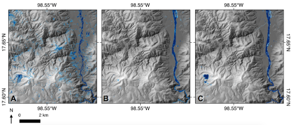
- I completed my Masters degree in Geographical Information Science at the University of Edinburgh in 2018, excelling in courses on spatial modelling, data visualisation and storymapping, web mapping, remote sensing analysis and machine learning. My dissertation project "Simplistic hydrodynamic modelling and satellite imagery calibration: predicting landscape response to cyclonic precipitation in Southern Mexico" assessed the relationship between flood rasters produced by cyclonic precipitation fed into the hydrological model HAIL-CAESAR, and floodwater extent automatically extracted from Sentinel-2 imagery of the same cyclone event.
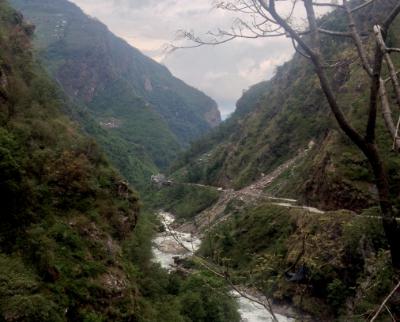
- Prior to my Masters degree, I completed my Undergraduate degree in Geology & Physical Geography also at the University of Edinburgh. My dissertation project "Topographic analysis of earthquake-induced landsliding: A focus on Central Nepal" I evaluated the distribution and topographic characteristics of over 5,500 landslides that occurred as a result of the Gorkha 2015 earthquake that affected much of Nepal. In this three-part analysis, I identified channel steepness as a potential proxy for coseismic landslide occurrence across the Nepali Himalayas.