

‘Right size, right place’ approach required for climate adaptation plans
Published: 27 June 2025
The outcomes of a new study on the extent of future flooding caused by climate change along the Clyde Estuary could help coastal cities around the world better defend themselves against rising tides and extreme weather.
The outcomes of a new study on the extent of future flooding caused by climate change along the Clyde Estuary could help coastal cities around the world better defend themselves against rising tides and extreme weather.
Sophisticated computer modelling of the Clyde by researchers at the University of Glasgow suggests that urban planners will need to adopt a ‘right size, right place’ approach to tidal flood management in the years to come.
Sea level rise has been accelerating since 2000, and will continue to rise for hundreds of years even if plans to reach net-zero by 2050 are achieved. Rising seas will bring increased tidal flood hazards for people and property.
The team’s research shows larger estuaries like the Clyde, which covers 120 square kilometres, are at greater risk of damaging floods because they connect directly to the sea.
Their study demonstrated that, during extreme weather events, vast additional volumes of tidal seawater will be carried onto land along the banks of the Clyde.
The team say that adapting to these additional flood waters means that larger, strategic interventions will be required to allow tidal floodwater to collect and drain without causing extensive damage to land surrounding the Clyde.
At the same time, they found that the tidal flood hazard for cities built near smaller estuaries could still be significantly lowered with smaller-scale interventions. This is because larger estuaries attract larger tidal volume during extreme events like storm surges.
Their findings could help fine-tune the effectiveness of many cities’ plans for alleviating flood risk, particularly managed realignment, an increasingly adopted method of mitigating flood risk by giving space for tidal flooding. It aims to use a more sustainable, nature-based approach to minimise the damage tidal floods can cause to low-lying coastal towns and cities, which are currently home to around 60% of the world’s population.
Instead of building sea walls around cities to keep flood waters at bay – which fight rather than work with nature – managed realignment encourages the cultivation of natural wetland areas like saltmarshes along estuaries to absorb and slow down tidal flood waters. It also advocates for moving people and buildings away from areas at risk of being overtaken by flood water and avoiding new construction in areas likely to be worst-affected by tidal flooding now and in the future.
In a new paper published in the journal Environmental Research Letters, the team from the University of Glasgow’s School of Geographical & Earth Sciences discuss the outcomes of their modelling, which is built on data from a hydrodynamic model recently commissioned by Glasgow City Council.
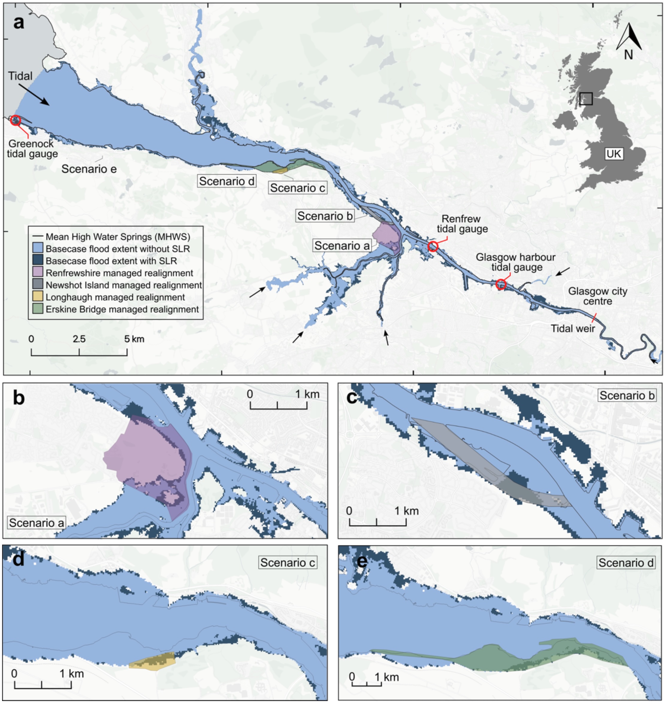
Their model tested scenarios for extreme tidal flood events by simulating how tidal flood extent will change for different combinations of managed realignment areas in Renfrewshire, Newshot Island, Longhaugh and the Erskine Bridge. These scenarios explored different sizes of intervention, ranging from 0.15 to 3.3 square kilometres.
The researchers modelled the effectiveness of the managed realignments against worst-case-scenario flooding along the Clyde, both in the present and for a projected year, 2100. In 2100, sea level is projected to rise an additional 85 cm under a high-emissions climate scenario.
Their simulations showed that the effectiveness of managed realignment was limited in preventing the spread of flood waters. In the present-day scenario, tidal flood waters covered 13.6 square kilometres of land along the Clyde without any managed realignment. In the 2100 scenario, water covered 19.2 square kilometres. With managed realignment measures in place, the extent of the flood was reduced by between 0.32% and 9.76%.
Dr Octria Prasojo is the paper’s corresponding author. He said: “We were surprised by the results, which showed that managed realignment measures along the Clyde Estuary produced smaller reductions in tidal flood extent than we might have anticipated even when more than three square kilometres of space is devoted to tidal flood management."
Paper co-author Dr Martin Hurst said: “For many cities built next to river systems, the volume of water which can contribute to flooding is limited by the amount of water which comes from the upstream river flow or rain. In the case of cities like Glasgow, however, where rivers are connected to the sea, the volume of water which can contribute to tidal flooding is vastly increased.”
The team’s paper also examined data from previously-published studies of managed realignment efforts in eight others estuaries across the UK, each smaller than the Clyde up to a maximum of 108 square kilometres. They found a correlation between the size of those estuaries and the effectiveness of their managed realignment – the smaller the estuary, the more effectively flood waters could be managed by managed realignment. For every 20% relative increase in the size of managed realignment, flood waters could be reduced by around 14%, the team showed.
Dr Prasojo added: “What we’ve found in this study is that managed realignment works very well when appropriately-sized locations are chosen to deal with tidal flood waters, and it works particularly well in smaller estuaries. However, there comes a point where that alleviation strategy starts to require larger and larger areas of land to be devoted to managed realignment, which may not be practical in more densely-populated areas. Effectiveness depends on where and how large managed realignment is allocated relative to the size of the estuary."
Professor Larissa Naylor, a co-author of the paper, said: “We hope the results will help lead to better-informed urban planning to mitigate the effects of climate change as sea levels rise and extreme weather events become increasingly common.”
The research is one of the outcomes from the Glasgow as a Living Lab Accelerating Novel Transformation (GALLANT) project, led by the University of Glasgow’s Centre for Sustainable Solutions. GALLANT, which is supported by £10.5m from the Natural Environment Research Council, is working with 29 programme partners including Glasgow City Council to develop new methods of climate resilience which also address health, social and economic inequalities.
Professor Jaime Toney is GALLANT’s principal investigator. She said: “What this study shows clearly is that cities built on estuaries will need to carefully consider how they plan to mitigate the worst effects of climate change-induced tidal flooding in the years to come.
“Adopting a ‘right size, right place’ approach to managed realignment will be key to ensuring that infrastructure damage is minimised, along with the associated costs of repair. For many cities, that will mean making informed decisions about new structural developments and land uses that are close to the water, and long-term planning that considers future flood risks appropriately within the wider context of conflicting land-use priorities and societal needs.”
Professor Richard Williams, Professor Larissa Naylor and Dr Martin Hurst of the University of Glasgow’s School of Geographical & Earth Sciences co-authored the paper. The team’s paper, titled ‘Right size, right place: scale-dependency of managed realignment to mitigate flood hazards in urban estuaries’, is published in Environmental Research Letters.
First published: 27 June 2025
<< June