

Methodology
Reconnaissance
Reconnaissance, which began in 1998 and was completed in 2004, aimed at recovering archaeological cropmarks, primarily in cereal crops. Accordingly, flying was undertaken in two separate phases, in early June and early July, to allow for the variations in the development of different crops. On average some 25-30 flying hours were undertaken each summer from the grass airstrip of the flying club at Deva utilising various high-winged light aircraft according to availability. Sites were recorded on both medium format black and white film and colour slides, and the flight paths logged by GPS.
The first two seasons produced very limited results in terms of cropmarks, since they were particularly wet. Fortunately, the final season of the pilot project in 2000 was extremely dry, one of the driest summers in Romania for some 20 years according to local farmers, and the summers of 2002-2004 during the second phase of the project were also reasonably dry. As a result large numbers of negative cropmarks or parchmarks have been recorded, indicating the presence of stone-walled buildings beneath the soil. Examples of positive cropmarks (e.g. ditches or pits) have been surprisingly limited.
At times the local cultivation system has proved to be an impediment to site visibility from the air, particularly in areas of strip-fields, since the creation of cropmarks is heavily dependent on the type of vegetation coverage. The extensive plan of the Roman military vicus at Micia (illus 4) is the result of sustained survey over several years during which different parts of the site became visible as crops were rotated.
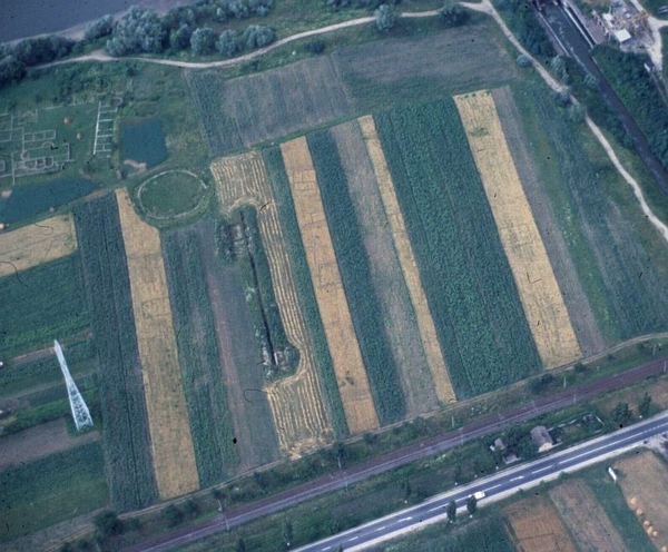
Illus. 4 Buildings showing as negative cropmarks immediately S and W from the small amphitheatre at Micia from the air, July 2000. Copyright W.S. Hanson
Post-reconnaissance
Sites discovered from the air have been integrated into a coherent system within a relational database and used to amplify what is known from previous research. The rectification and geo-referencing of the oblique aerial photographs, which is ongoing, has utilised AirPhoto software. Background maps at a suitable scale (1:5000) were obtained through the auspices of the National Museum of Transylvania. Where such maps were not available, either Corona satellite imagery was substituted or hand held GPS (Global Positioning System) technology was used to establish the geographical co-ordinates of control points on the ground. These rectifications have then been imported into ArcView GIS to facilitate interpretation, mapping and the creation of site plans (illus 5).
The background for analysing the flight track records, location of sites and their analysis in the context of modern topography or land use was provided by a combination of scanned 1:50000 maps and LANDSAT-5 satellite data. The resultant base maps provide an overview of the development of the landscape through time.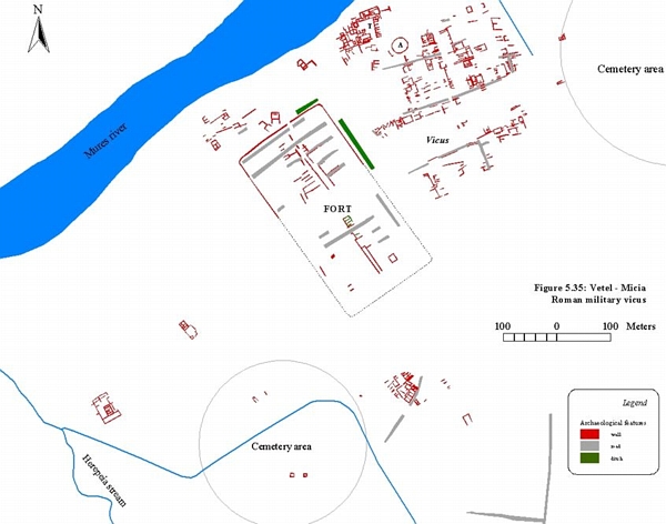
Illus. 5 Plan of vicus at Micia. Copyright I.A. Oltean
- Introduction
- People
- Geography
- Methodology
- Achievements
- Publications