

Achievements
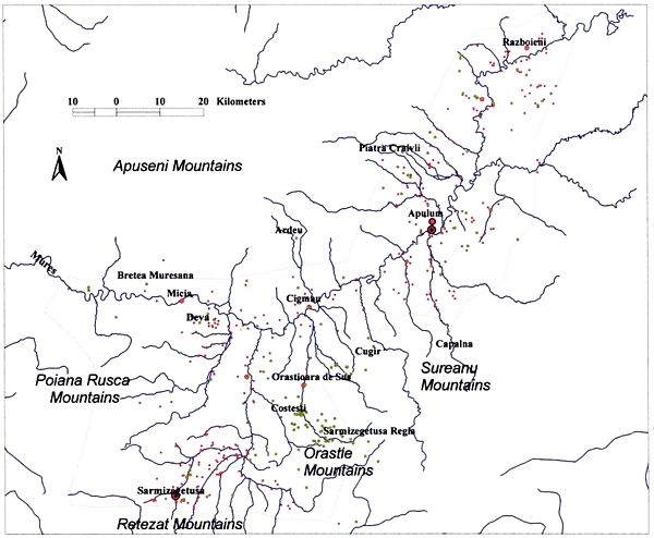
Illus. 6 Distribution map of Dacian and Roman settlements in the study area. Copyright I.A. Oltean
This project has demonstrated that aerial reconnaissance has the potential to revolutionise Romanian archaeology. A major contribution has been made to the understanding of the Roman period in particular, both in relation to known site foci and to new sites (illus 6), but discoveries extend from the Neolithic and Bronze Age to the archaeology of the two World Wars. Important discoveries include:
- Auxiliary forts with their associated civil settlements (vici) at Micia and Cigmau
- Buildings within both the colonia and muncipium at Apulum (Alba Iulia)
- Roman villas at Oarda and Vintu de Jos, the latter showing settlement continuity from the Dacian period
- Iron age settlements at Uroi and Simeria
- Medieval and undated settlements at Miraslau and Cozia
Roman auxiliary forts and vici
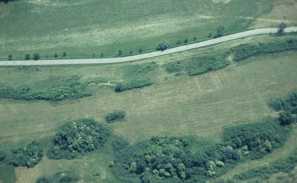
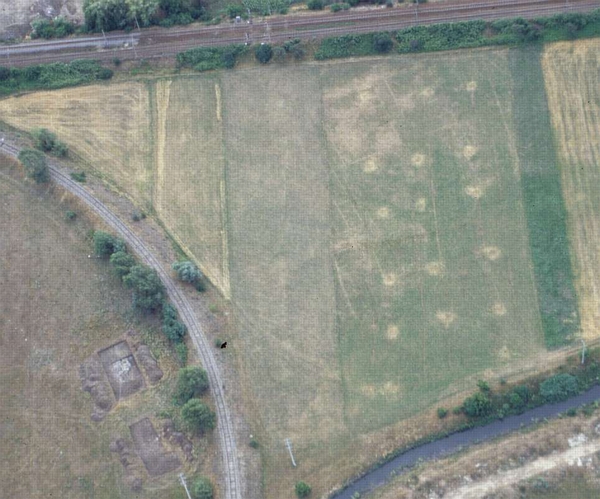
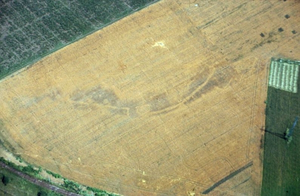
The Roman fort at Micia is situated on the south bank of the Mures. Despite many years of excavation, the new aerial discoveries dramatically expand understanding of the extent and layout of the associated civilian settlement, which is clearly considerably larger than previously thought (illus 4 and 5). Buildings are now attested on all sides of the fort, though the main focus of activity remains to the north and east. The layout of the vicus indicates a considerable level of planning control and organisation for the use of space is highly structured: systems of roads are apparent forming a loose grid pattern and individual properties seem to have been well delimited by passageways or alleys.
Two rectangular buildings associated with yards containing ancillary structures are located some distance to the west of the fort and three small rectangular buildings to the south-west, one with an apse, may represent temples or mausolea.
Illus. 7 The Roman fort at Cigmau from the air, June 2000. Copyright W.S. Hanson
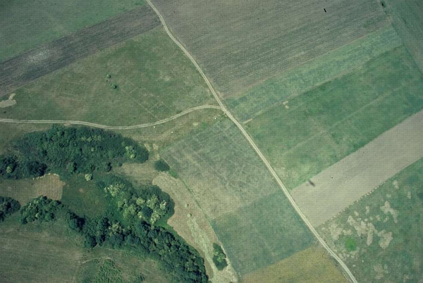
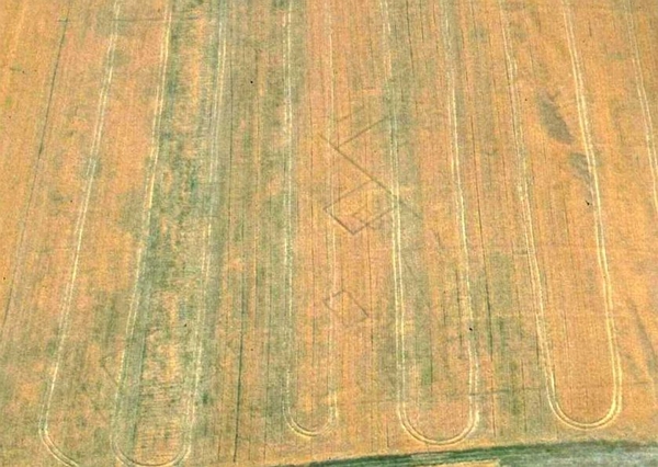
The site of the fort at Cigmau (Germisara) sits at the end of a low, narrow spur some 150m to the north of the river Mures. The topography of the spur determined the shape of the fort, which would have been long, narrow and certainly irregular. Aerial photographs revealed the plan of its central buildings and the position of its stone defensive walls on two sides (illus 7).
The existence of an associated civil settlement was known on the basis of archaeological material discovered in the fields to the east of the fort, though its nature and extent was unclear. The cluster of buildings revealed by parchmarks and negative cropmarks began immediately beyond the eastern rampart of the fort, but the focus of the settlement lay on the flatter ground to the north east, extending at least 370m from the east gate (illus 8). The vicus settlement was laid out on a north-west/south-east alignment, with a rudimentary street grid subdividing the main settlement area. One road leads further east beyond the settlement, and is probably the main road of the province. Different building alignments are suggestive of at least two phases of construction.
Illus. 8 Vicus buildings to the east of the Roman fort at Cigmau from the air, June 2000. Copyright W.S. Hanson
Urban buildings
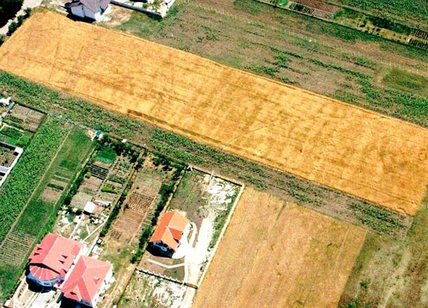
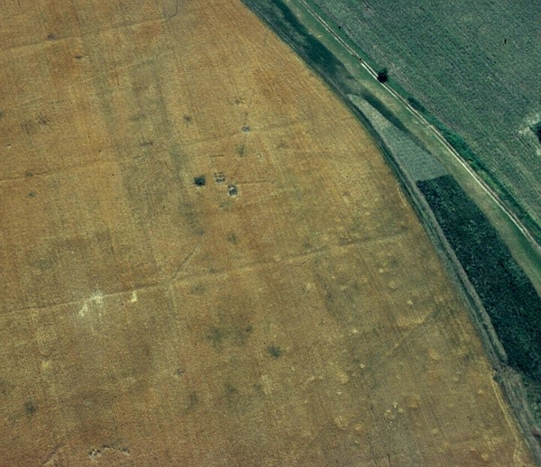
The precise limits of the two civil settlements located immediately outside the legionary fortress at Apulum (Alba Iulia) are far from clear. On the southern edge of the historic town within the area of the municipium aerial reconnaissance in 2000 revealed a series of properties quite close together, demarcated by stone walls, containing simple rectangular buildings (illus 9). Previous fieldwalking and limited rescue excavation in the general area have confirmed the presence of Roman ceramics and building materials. Further to the south at Partos in the north-western quadrant of the colonia reconnaissance in 2003 revealed a range of buildings representing parts of more than three residential insulae in the north-western quadrant of the town (illus 10). A group of small pits and a small rectangular building (probably a mausoleum) located to the north of the town adjacent to Roman roads indicate the site of a major cemetery.
Illus. 9 Roman buildings within the municipium at Apulum (Alba Iulia), July 2000. Copyright W.S. Hanson
Illus. 10 Roman buildings within the colonia at Apulum, July 2003. Copyright W.S. Hanson
Roman villas
Some 1.5km to the south of Oarda village, approximately 4km south west of Alba, a Roman villa was revealed as a series of negative cropmarks in a ripening cereal crop (illus 11). It lies on raised ground by a small stream overlooking the river Sebes on its west side. A visit to the site in August 2001 indicated that the surface of the field was littered with Roman building materials. The remains are quite extensive, spreading across an area c. 100m by 120m. There appear to be a number of separate building ranges, some showing signs of subdivision, grouped around three sides of what was probably a large central courtyard. Overlapping one of the buildings on the south side is a small, subdivided rectangular structure, suggesting that occupation of the site went through at least two distinct phases.
Illus. 11 Roman villa complex at Oarda, June 2000. Copyright W.S. Hanson
The site at Vintu de Jos is situated on the first terrace of the Mures River. A cluster of oval sunken houses and storage pits of an Iron Age settlement are located adjacent to the remains rectangular buildings showing as a negative cropmark (illus 12). Its Roman date and identification as a villa was confirmed by the discovery of tegulae during a site visit. Subsequent excavation on the site under the auspices of the Apulum Hinterland Project indicated Dacian and Daco-Roman occupation.
Illus. 12 Vintu de Jos, villa and Dacian/Daco-Roman settlement, July 2002. Copyright W.S. Hanson
Iron age settlements
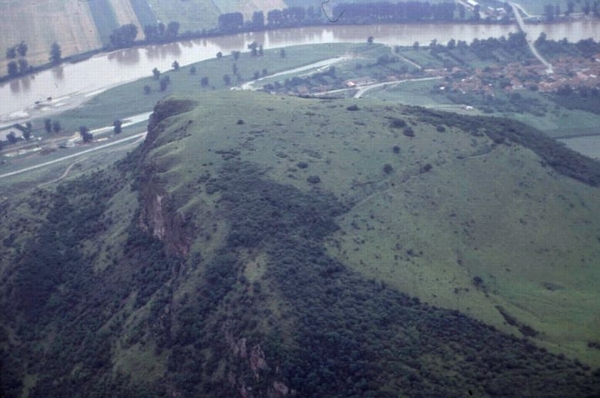
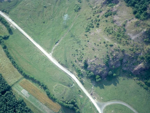
Uroi Hill is an andesite plug which projects into the valley of the Mures approximately 9 km east of Deva, and stands up to 200 metres above the valley floor. The hill is approximately triangular in shape with a largely flat top, sloping downwards slightly to the north-west, and is best known as a stone quarry used since at least Roman times. It sits in an important strategic position directly overlooking the confluence of the Mures and the Strei rivers, with excellent views along their valleys to west, east and south. Aerial photography revealed a previously unrecognised extant rampart and ditch which had the effect of cutting off the upper part of the hilltop and creating a promontory fort, probably of Hallstatt date, enclosing an area of some 6.5 hectares (illus 13).
Illus. 13 The Iron age promontory fort on Uroi hill, July 1999. Copyright W.S. Hanson
The multi-period cropmark site at Simeria is located to the west of the modern town of the same name. Some pits indicate sunken houses and others of smaller dimensions probably represented storage pits (illus 14). However, the most striking feature is a partial curvilinear enclosure with one entrance following the natural edge of the river terrace. It consists of ditches some 3 metres in width (doubled to the south of the entrance where the natural slope of the terrace is less steep). In the interior the narrower ditches probably of a palisaded enclosure turns outwards at the entrance to connect with the ditch in front of it. The finds discovered during a site visit in 2002 included prehistoric pottery also of Dacian date, along with some Roman and later sherds.
Illus. 14 Simeria, pits and curvilinear enclosure of Dacian settlement. Copyright W.S. Hanson
Medieval and undated settlements
In the hills immediately to the south-west of Deva at Cozia, a scattered group of small, irregular rectangular features on either side of the modern road visible from the air appear to be stone-built structures and may represent a quarry settlement of possibly Roman or medieval date (illus 15). They are not necessarily contemporary with the adjacent circular enclosure, c. 20m in diameter, constructed of irregular stones.
Illus. 15 A group of small, irregular rectangular stone-built structures at Cozia, June 2000. Copyright W.S. Hanson
At Miraslau in the upper Mures valley an extant sub-circular earthwork was recorded from the air (illus 16). It has the characteristics of a medieval fortified enclosure, including projecting towers. Despite its obvious characteristics, the site is apparently previously unrecorded.
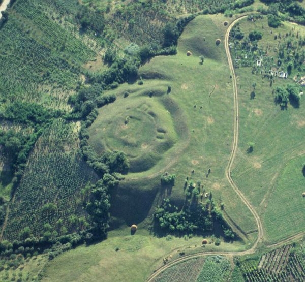
Illus. 16 Extant medieval fortified enclosure at Miraslau, June 1999. Copyright W.S. Hanson
- Introduction
- People
- Geography
- Methodology
- Achievements
- Publications