

In and Around Fortevtiot in 2011
In 2011 a series of investigations took place in and around Forteviot Village. Excavation trenches were opened in the manse garden, in Forteviot Churchyard and at Haly Hill.
Manse and Paddock
As part of the SERF project two trenches were excavated in the grounds of the former Manse in Forteviot village.
A small trench was opened in the Manse paddock field. Very deep deposits of 19th and 20th century garden soil prevented exploration of a large area. A sondage trench showed only one feature, cut into the natural gravel. This appeared to be a ramped post-hole, similar to, but smaller than, the early prehistoric post-holes excavated in the ceremonial complex in the field to the south.
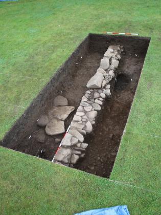
Another trench, measuring 15 square meters, was excavated in the gardens of the former Manse produced a variety of structural features, including a wall and stone paving, overlying a pit associated with industrial activity. The major feature was a linear drystone revetment wall which was interpreted as a property division which may have delimited church or monastic lands in the medieval period. This is aligned with a ditch excavated last year.
Fortevtiot Churchyard
Two trenches were excavated in the Forteviot Churchyard. One, a narrow trench situated at the east end of the Church, revealed a series of structures and building phases relating to the church including the foundations of late 18th or early 19th century external stairs, the foundations of the 1778 church building, and at least two phases of medieval building. These phases included what is interpreted as a stone medieval foundation wall and part of a structure added onto the East end later in the medieval period. Finds of stone slates and decorated window glass suggest the medieval church building was a substantial and impressive structure.
The second trench, located in an unused cemetery plot within the modern extension of the Forteviot Church graveyard, uncovered a previously unknown cemetery of up to seven west-east oriented dug graves, as well as undated oval pits and one possible timber slot trench.
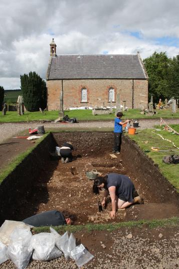
The graves and other cut features were sealed by a 1m-deep overburden of soil containing mainly modern midden material, possibly ‘night soils’ dumped from the nearby manse. Each grave consisted of simple earth-cut pits oriented west-east; human teeth and heavily eroded bone fragments were found in two of the graves, confirming that the head was placed at the west end of the graves. Although not fully excavated, two possible graves had a rough stone slab capping; one of these was partially chisel-worked. The largest grave cut was associated with a circular posthole at its southeast corner, resembling the similar features surrounding the central burials in the conjoined square barrows excavated outside Forteviot in 2007 (NO01NE 29).
In addition, a structural timber-beam slot and a linear arrangement of small oval pits were found in close association with the graves. The timber beam slot had a posthole at one end, indicating a possible structural function. This was aligned west-east and was seemingly respected by the graves, but did not clearly act as a burial enclosure, and remains undated.
Haly Hill
Several trenches were excavated at Haly Hill, in the west end of the village of Forteviot. Portions of two post-medieval buildings, the remains of an old road and associated farmyard structures were uncovered.
The larger of the two buildings revealed to be a byre dwelling constructed in the late 18th or early 19th century which was later demolished when the village was remodelled in 1925. This structure had undergone several phases as it was transformed from a cruck-framed structure with clay-bonded walls to rough cast mortared walls during the course of its life.
The other building, not fully excavated, may have had its origins in the 17th century. Subsequently the building site was occupied by a smithy. Copious quantities of slag, coal ash, clinker and smithing waste as well as numerous iron objects were uncovered. The walls of this structure had been heavily robbed, but were clay-bonded. Only three walls were located suggesting that the side facing towards the road was open. At a later date the interior was paved and transformed in to a byre.
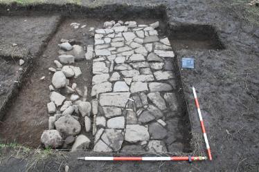
At the north end of the site, a trench was excavated over an old road noted on the 1st edition Ordnance Survey map. It consisted substantially of clay with a cobble base. Wheel ruts were still visible within the gravel metal. Adjacent to the road to the east was an extensive area of fine pebble paving which was interpreted as a farm yard. This area overlapped with Alcock’s 1981 excavations.