

Leadketty Excavations 2013
 Excavations at Leadketty in 2013 focused on a putative Neolithic causewayed enclosure 2km north of Dunning (near Baldinnies steading) and 500m north of the late Neolithic Leadketty palisaded enclosure (the target of our work in 2012). The enclosure is a cropmark discovery, sub-circular in form and defined by a single wide ditch with multiple entrance gaps. SERF fieldwalking in this vicinity in March 2013 revealed no artefacts of note. Geophysical survey over this enclosure complemented the information gained by comprehensive cropmark record in this location.
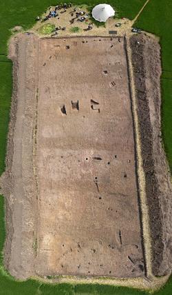
The excavation trench covered an area measuring 50m by 20m on the southern side of the enclosure, concentrating not just on the ditch, but also internal and external features recorded from the air and during the geophysical survey. During the three week excavation, we found no diagnostic material culture, despite identifying and digging dozens of cut features; it is to be hoped post-excavation analysis will enable us to date the various features we found. The identification of features was problematic due to the dry weather encountered during the excavation, and a series of very wide plough furrows running across the trench had damaged some of the earlier features.
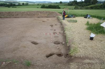
The ditch of the putative causewayed enclosure was sampled in three places and shown to be shallow, no more than 67cm deep, and up to 2.66m in width. The fills were relatively clean silts that had washed in naturally from the surrounds. We identified one terminal, demonstrating that the entrance gap on the south side of the enclosure is indeed genuine, and not a product of differential cropmarking. No trace of a bank was found. A wide range of features were found within this ditched enclosure although none of these could be connected, stratigraphically to the enclosure itself. These consisted of clusters of small cut features including stake- and post- holes, pits, hollows and a slot that once supported a light fence or screen; some of the features were intercutting. A few of the postholes within the enclosure may have belonged to structures: a circular setting, a straight line of small posts and an arc of larger postholes, but the relative chronology and function of these features was unclear. Fragments of cremated bone were identified in several features, but none represented a burial, while post 18th century ceramics and corroded metal objects were found in several pits.
 Outwith the enclosure, two main features were identified, and again chronologically we could not tell how these related to the causewayed ditch enclosure. A ring ditch 15m in diameter with a small entrance gap on the eastern side and a few small internal postholes was investigated; the ditch perhaps supported a fence. This feature cut a posthole which was found to be part of an arc of posts, which we interpreted as a rather substantial palisade or fenceline. A possible entrance gap in this palisade, with large postholes flanking it, was identified. Both the ring ditch and palisade are visible as cropmarks on a few air photos, although it is difficult to tell is the palisade represents part of the continuous boundary of a large timber-post defined enclosure following roughly the route of the causewayed enclosure, or if it is some kind of elaborate entrance arrangement, or simply a fenceline.
The question of whether the causewayed enclosure should continue to be included in Neolithic studies remains unresolved. However, we have identified what appears to be a complex multi-phase occupation site, mostly we would argue representing prehistoric activity.