Environmental Sciences PhD/MSc (Research)/MPhil (Research)
Self funded opportunities (MSc by Research)
+++
Holocene paleoclimate changes inferred from lipid biomarkers and geochemical analysis from Dubh Lochan, Scotland (Dr Bianca Cavazzin and Dr Antonio García-Alix)
Supervisors: Dr Bianca Cavazzin, Dr Antonio García-Alix (University of Granada)
Project overview: This proposed master's project aims to unlock the paleoclimate secrets hidden within the Dubh Lochansediment core, spanning approximately 10,000 years before present (cal BP). By employing a multi-proxy approach, integrating geochemical and lipid analysis with statistical techniques, the study aims to construct a comprehensive narrative of climatic and environmental changes in the region.
The project will focus on the analysis of Dubh Lochan sediment core, targeting molecular compositions of n-alkanes and conducting compound-specific stable isotope analysis on. These geochemical proxies offer invaluable insights into past climatic conditions, providing a window into temperature variations, vegetation changes, and hydrological cycles over millennia. The project adopts a holistic approach by integrating the organic geochemical data with complementary datasets already collected, such as grain size and magnetic susceptibility. Through statistical investigation, the student willestablish robust connections between different proxies and unveil past climate dynamics. This interdisciplinary approach not only enhances the reliability of interpretations but also fosters a deeper understanding of the complex interplay between various environmental factors.
Ultimately, the insights gained from this research will provide valuable perspectives for assessing future climate trajectories and informing strategies for environmental conservation and management in Scotland.
Skills development: During this project the student will develop transferable and subject specific skills includingindependently managing a research project, critical thinking, working collaboratively with external partners, taking responsibility for own learning and development, communicating ideas effectively, analytical techniques including gas chromatography mass spectrometry, sediment analysis, data interpretation and statistical analysis using R studio.
Requirements: The applicant would have an interest in conducting a laboratory-basedproject in organic geochemistry. A background in chemistry/ geology/ environmental geoscience is desirable, however training on specialist laboratory techniques will be provided.
---
+++
Hydroclimate reconstruction from Llangorse Lake (South Wales) across the Loch Lomond Stadial (Dr Bianca Cavazzin and Charlotte Slaymark)
Supervisors: Dr Bianca Cavazzin and Charlotte Slaymark.
External partner: Royal Holloway, University of London.
Project Overview: One of the most impactful consequences of anthropogenically induced climate change is the damage caused by changes to the hydroclimate (IPCC 2022). Instrumental records show that extreme variability is a key feature of hydroclimate during rapid climatic transitions (Kendon et al., 2021). However, evidence of how the changing hydroclimate will drive large-scale ecosystem change requires assessment of climate on longer timescales than the instrumental period provides. As such, the ‘ Loch Lomond Stadial’ (LLS), ca 12.850 – 11.650 years before present provides a ‘natural geological laboratory’ to study the effects of hydroclimate during periods of rapid temperature change in the United Kingdom.
Project Aim: The aim of this project is to reconstruct hydroclimate across the LLS from a lake sediment archive from Llangorse Lake, South Wales, a site chosen for its outstanding chronological resolution. Organic geochemical and compounds specific isotope proxies will be used and paired with cutting edge statistical analysis to contextualise the proxies.
During this project the student will develop transferable and subject specific skills including: independently managing a research project, critical thinking, working collaboratively with external partners, taking responsibility for own learning and development, communicating ideas effectively, analytical techniques including gas chromatography mass spectrometry, sediment analysis, data interpretation and statistical analysis using R studio.
Requirements: The applicant would have an interest in conducting a laboratory-based project in organic geochemistry. A background in chemistry/geology/environmental geoscience is desirable, however training on specialist laboratory techniques will be provided.
---
+++
Characterising the headwaters of the Glen Luce catchment with a focus on the peatland extent around the Water of Luce and how this relates to the water quality data (Dr Ed Curley and Dr Bianca Cavazzin)
Supervisors: Dr Ed Curley and Dr Bianca Cavazzin.
Outcome: A better understand of the Glen Luce (particularly the Water of Luce) geology, land use and severity of peatland degradation, and how this might relate this to the water quality monitoring results (particularly DOM) to provide some explanation and context. This understanding can then be used in communications with stakeholders or potential applicants providing a strong/robust case. E.g. In a catchment where the land use is x% (tbd) highly drained deep peat peatland restoration is likely to improve water quality parameters A, B within (tbd) years .
Summary: Water quality monitoring (including DOM) has been undertaken at five locations in the watercourses of the upper Water of Luce catchment, here there is significant degraded peatland which has been drained to improve the land for sheep grazing. It is hoped that restoration work will be undertaken in these peatland areas in the coming years and a better understanding of the geological and soil profiles of the catchment along with the land use (current and historic changes) would help in the assessment of the effect of restoration on water quality. Potential data types that could be of interest include (but are not limited to) – GFT Water quality data, SEPA flow data, geology maps, soil maps, broad vegetation classes, Lidar (part of catchment), some scattered fish count data.
External partners: Peatland Action and the Galloways fisheries trust
---
+++
Comparing pH levels in watercourses in the upper Water of Fleet river catchment with geology, soil type and land use (Dr Bianca Cavazzin and Dr Ed Curley)
Supervisors: Dr Bianca Cavazzin and Dr Ed Curley.
Outcome: A better understanding of how pH levels related to land use, geology and soil types in the upper Water of Fleet. This understanding can then be used in communications with stakeholders or potential applicants providing a strong/robust case for peatland restoration.
Summary: The headwaters of the Water of Fleet in SW Scotland have been subject to the effects of acidification. Whilst the area appears to be in recovery the rate of recovery is slow and water quality is still significantly impacted in many areas. Much of the upper river is covered in commercial Sitka spruce forestry with many blocks of forestry planted on degraded deep peat. Both are known to amplify the impacts of acidification. In contrast one sub-catchment within the upper river is a National Nature reserve (Cairnsmore of Fleet) which is largely unplanted and has been subject to ongoing peatland restoration. Water quality data (including pH) is available from three sites within the forested section of the upper river, whilst data is also available from within the nature reserve (albeit from a different time period). The data will allow variations in pH levels to be compared between with land use, soil type and flows to determine the factors influencing pH levels.
External partners: Peatland Action and the Galloways fisheries trust
---
+++
Microbial abundance and distribution within glaciofluvial sediments (Dr Karen Cameron)
Supervisor: Dr Karen Cameron
Project
Melting glaciers release an abundance of glacial sediments, nutrients and microbiota. Glacial sediments that settle downstream establish physical matrices where new microbial ecosystems can develop. To date, little is known about the ecology of these sediment systems, however they have the potential to play key roles in nutrient cycling and biological weathering reactions within periglacial environments.
This project will establish foundation knowledge on the ecology of these systems through the following research objectives:
- Determine the abundance of microbial cells within glaciofluvial sediments
- Establish how cell abundance varies with sediment depth and distance from the glacier
- Investigate whether cells preferentially associate with certain sediment grains or with pore waters
- Analyse whether cell abundance and distribution varies with physicochemical parameters such as pore water chemistry and sediment grain size
To address these research objectives, the candidate will work on sediment core samples taken along a 30 km transect of Watson River in southwest Greenland, which drains a portion of the Greenland Ice Sheet. These samples will include cores taken from the glacial margin, from glaciofluvial sandurs, and from the head of Søndre Strømfjord, a fjord that connects Watson River to the open sea. Cellular analyses and imaging will be performed through classical and fluorescence microscopy, and through scanning electron microscopy. Sediments will be analysed through size fractionation, their chemical composition will be investigated through Raman spectral mapping, and their surrounding water content will be evaluated through mass changes on evaporation. Results will be statistically compared alongside pore water chemistries to determine the likely drivers of microbial abundance and distribution.
Required background
The successful applicant should have a background in geographical or biological disciplines such as Geography, Earth Science, Environmental Science, Geosciences, Geobiology, Ecology or Microbiology. The applicant should have a minimum of 2:1 (or equivalent) in their bachelor degree. Those with experience in laboratory work, ecological surveys, statistics and a willingness to learn are particularly encouraged to apply. Enthusiasm and evidenced proven ability to work and think independently are highly desirable.
Career prospects
The successful candidate will work towards a MSc degree which will place them competitively within the career market. Ideally, they will produce a per-reviewed publication from this work, which will be an invaluable asset to their portfolio. They will learn and practice a variety of transferable skills, including research design, execution and reporting; cell imaging and quantitative analysis; geochemical processing; and statistical analyses. Such skills are highly sought after by a wide variety of employers, including those within the environmental sciences, ecology, water quality and soil sciences sectors. The candidate will be excellently positioned to pursue further studies as a PhD candidate.
Additional programme cost: £500
---
+++
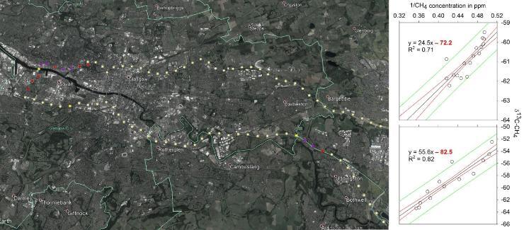
Fugitive methane in Scotland: Plume mapping and isotopic characterisation using Cavity Ring-down Spectrometry (Dr Adrian Bass)
Supervisor: Dr Adrian Bass
Proposal:
Methane (CH4) has a global warming potential 28-36 times greater than that of carbon dioxide (CO2) and thus, its formation, distribution, stocks and fluxes require our understanding. Atmospheric methane concentration has increased significantly since the industrial revolution, but our knowledge of local and regional production processes is still limited. Where it is, where it comes from and how did it get there are questions still needing exploration at the finer scales.
Utilising the stable isotopes of carbon we can begin to elucidate the origin of a methane source, allowing for the separation of anthropogenic and natural sources to the atmosphere on small spatial scales. To assess the contributions from anthropogenic activities such as mining (active and retired), agriculture, and natural gas extraction via hydraulic fracture we use high resolution measurements of methane isotopic composition. Specifically in this project we will use Cavity Ring-down Spectrometry to map and characterise methane plume distribution across Scotland’s central belt, quantifying the significance of anthropogenic and natural methane sources on a regional scale.
Specific and transferrable skills
The student will gain expertise in carbon isotope analysis via Cavity Ring-down Spectrometry and isotope ration mass spectrometry as well as general laboratory practice. Stable isotope analysis and use are widely used in numerous fields of study and training in their application will be a valuable asset. Unique to this project, the student will become versed in the relatively new technology of Cavity Ring-down Spectrometry, a rapidly expanding methodology in biogeochemistry. This will include extensive utilisation during field campaigns.
Required background
The student will likely have a background in chemistry, geology or environmental geoscience, with an interest in developing this into a comprehensive biogeochemical framework. Laboratory experience is desirable though not essential, as is experience with field work. A willingness to learn techniques not already possessed is essential. A competent ability in scientific writing, gained during an undergraduate dissertation, is expected.
---
+++
Energy-efficient alteration of natural algal products for use in biofuel technology (Dr Jaime L Toney)
Supervisor: Professor Jaime L. Toney, Dr Ian Watson (School of Engineering, University of Glasgow), Dr David France (School of Chemistry, University of Glasgow)
Proposal
The main objective of this project is to determine which processes are the most energy-efficient for converting the natural algal molecules into biofuels.
Dependence on fossil fuels is one of the most critical challenges facing modern society and research into renewable and sustainable sources of fuel are essential as society moves forward. One of several “Green” solutions to the looming global energy crisis is the generation of biofuels from plants. Producing ethanol from corn is one potential strategy, although this process currently has a finely balanced energy requirement (i.e. about the same amount of energy goes into producing the ethanol as comes out). An attractive alternative would be to use aquatic plants like algae, which can be “farmed” much more efficiently and do not carry concerns of soil nutrient depletion. Algae have recently been discovered from lakes with unusual water chemistries that produce high concentrations of high molecular weight ketones of varying saturation states.
This project will isolate these molecules from lake sediments using known organic geochemical techniques and investigate the experimental conditions needed to break these compounds into smaller, usable molecules for the biofuel industry. This project provides a key opportunity to work in a growing, interdisciplinary field with colleagues across the Schools of Geographical and Earth Science, Engineering, and Chemistry.
Specific and transferrable skills
Data analysis and problem solving, experimental design, leadership, mentoring, project management, oral presentation, expertise in organic geochemistry, effective proposal and report writing
Required background
Highly motivated student from Earth Science, Geography, Engineering or Chemistry backgrounds are strongly encouraged to apply. The successful candidate will have, or be about to receive, a Bachelor degree (at least 2:1 or equivalent).
Interested applicants should contact Dr Jaime Toney at: Jaime.toney@glasgow.ac.uk
---
+++
Antiquity and erosion of a rock shore platform in Scotland (Dr Martin D Hurst)
Supervisors: Dr Martin D. Hurst (University of Glasgow), Dr Larissa Naylor (University of Glasgow), Dr Derek Fabel (Scottish Universities Environmental Research Centre)
Project aim:
Determine the timing and rates of coastal erosion over millennial timescales using cosmogenic isotopes
Project rationale:
Coastal erosion threatens coastal infrastructure and livelihoods. Knowledge of past rates of coastal erosion is vital to improve our understanding of coastal processes and ultimately predict the future fate of our coasts under conditions of rising sea level and increased storm activity.
The Scottish coastline reflects a complex history of relative sea level change due to the interaction of changing volume of the oceans (eustatic sea level) with changing land elevation due to isostatic rebound. Both onshore and offshore, the Scottish coast shows geomorphological features that are remnant of past sea levels that are thought to date to the early Holocene, or to past interglacial periods.
This project will perform Cosmogenic isotope dating of modern shore platforms to determine if they are entirely modern features and to investigate how rapidly they have formed.
Methods
Rock samples will be collected from across a sandstone shore platform on the west coast of Scotland during low tide conditions and returned to the lab where they will be crush and sieved.
A topographic survey of the studied coast will also be conducted using an Unmanned Aerial Vehicle. Quartz will be isolated from the rock samples, which will then be cleaned and chemical separation procedures used to isolate Beryllium. The concentration of Beryllium will be measured by accelerator mass spectrometry. The resulting concentrations will be interpreted using a numerical models that predict cosmogenic isotope concentrations alongside the morphological evolution of rock coasts in response to changing relative sea levels.
Additional programme cost: £1,000
Knowledge background of the student
A student with a strong background in Geology and/or Physical Geography with chemistry would be ideally suited to this project. Courses that have covered geochronology, geochemistry and/or coastal processes will be advantageous. An additional benefit would be a strong quantitative background.
Career prospects
Knowledge of coastal processes and experience of coastal modelling could lead to positions in engineering and environmental consultancy. Training in analytical chemistry could lead to a variety of technical positions. This project would also lend itself well to further research such as a PhD position.
---
+++
Community monitoring of Scottish beaches vulnerable to erosion (Dr Martin D Hurst)
Supervisors: Dr Martin D Hurst (University of Glasgow), Dr Larissa Naylor (University of Glasgow), Dr Chris Blenkinsopp (University of Bath), Dr Alistair Rennie (Scottish Natural Heritage)
Project aim:
Investigate the dynamics of a Scottish beach considered vulnerable to erosion, through community engagement in beach monitoring
Project rationale:
Homes, businesses, transport links, rare ecosystems and important cultural heritage can all be found on Scotland’s coast. But 20% of Scotland’s coast is considered “soft” and potentially vulnerable to erosion. The risk of erosion is set to worsen given projections of sea level rise and increased severity and frequency of storms due to anthropogenic climate change.
Our ability to predict the future occurrence of coastal erosion requires robust observations of coastal change to understand past behaviour and develop knowledge of coastal processes. Therefore continued monitoring of coastal change is vital to understand the future fate of Scotland’s coasts.
Methods
Members of the public regularly visit beaches, and most now carry smartphones equipped with digital cameras. Additionally, social media platforms provide convenient means to rapidly share photographs. As a result, photo-point initiatives have started to emerge that encourage crowd-sourcing of images taken by the general public to monitor environmental change through time.
Installation of camera cradles in public space with instruction on how to collect and share photographs taken allow a database of coastal photographs to be developed. Knowledge of the camera position combined with high-precision GPS measurements of fixed points in the field of view allow georectification of these coastal images and the accurate mapping of shoreline position (Harley et al., 2019).
This project will establish a community shoreline mapping programme and use it to monitor shoreline changes across a winter storm season at a site in Scotland known to be vulnerable to erosion.
Additional programme cost: £1,000
Knowledge background of the student
The student should have a background in Geology, Physical Geography or Engineering, preferably including knowledge of coastal processes and coastal management. Experience using GIS software will be advantageous, as would a strong quantitative background, and experience of programming scripting e.g. Python, R or Matlab.
Career prospects
This project would equip a student with transferable knowledge and skills sought after across private and public organisations, as well as offering the potential to lead to further research at PhD level. Engineering, environmental and GIS consultancies, Government and public organisation such as local authorities, environmental regulators (e.g. SEPA), research organisations (e.g. CREW, SNH).
---
+++
Ground motion measurements for Earth Science using precise Global Navigation Satellite System (GNSS) techniques (Dr Elizabeth Petrie)
Supervisors: Dr Elizabeth Petrie and collaborators
Proposal:
GNSS has many applications in Earth science, from monitoring tectonic motion and deformation around volcanoes, to measuring glacial isostatic adjustment. A variety of projects would be possible and I would be happy to discuss possibilities. However, below is an example of one potential project:
The number of GNSS sites being operated in Antarctica has increased sharply in the last few years, and their record lengths are becoming potentially viable as robust indicators of vertical motion. However, the available Antarctic dataset is highly variable in terms of operator, equipment, collection purpose, and data quality. The project will assess the effects of snow cover on the antenna on the Antarctic GNSS time series. This will be done using Signal to Noise ratio data (SNR). SNR data consist of measurements of GNSS signal power relative to a receiver-calculated noise floor and are commonly reported by geodetic quality GNSS receivers and output to GNSS format RINEX files (Larson, 2013). Once the effects have been assessed, a set of improved timeseries will be generated
Specific and transferrable skills:
The student will develop skills in using one of the major scientific GPS software packages to process GNSS data to high precision. The student will also develop skills in Linux, data analysis and scientific writing, and gain experience of GNSS data collection.
Required background
The ideal situation would be for the student to have a background in the relevant area of Earth science to which they would like to apply the GNSS monitoring, as well as experience in using Linux, basic programming skills, maths, statistics, and an understanding of GNSS. In practice, a student who has experience in some of the areas should be able to learn the remaining ones (potential degree backgrounds - Earth Science, Physics, Mathematics, Computing Science, Geospatial & Mapping Sciences).
---
+++
Quantifying tropical river morphological change using satellite remote sensing (Dr Richard Williams)
Supervisors: Dr Richard Williams, Dr Brian Barrett
Project aim:
The aim of this project is to quantify rates of morphological change for a tropical river in an island archipelago.
Project rationale:
Rivers in South-East Asia are under considerable pressure from climate change, land use change and rapid urbanisation. Rivers in this part of the world also pose considerable risks to people, property and infrastructure, due to both flooding and morphological change from channel scour and bank erosion.
A recent workshop that was held between the University of Glasgow, and universities and consultancies from Indonesia and the Philippines, has revealed that there have been no studies to quantify rates of morphological change along tropical rivers in either of these archipelago nations. This represents a considerable gap in the global understanding of river morphodynamics across a representative set of rivers with different controls and styles. Moreover, this dearth of knowledge poses a considerable challenge for river managers in these countries since land use planning and natural hazard management decision making is not based upon knowledge of the natural active width of these river systems.
A first step in addressing this knowledge gap is to quantify morphological change by assessing river change using multi-temporal remote sensing imagery for a river that exemplifies tropical archipelago fluvial systems.
Methods
The project will focus upon the Cagayan River, which drains the northern island of Luzon in the Philippines. The Cagayan River is 520 km long with an estimated annual discharge of 53,943 million m3.
The objectives are:
- to collate annual time-series satellite imagery for the Cagayan River and its major tributaries
- to develop a volumetric sediment budget for the Cagayan River, using field estimates of river bank height and bar thickness, together with the map of river erosion and deposition
- to assess the Cagayan River’s rates and style of morphodynamic change as an exemplar of a tropical archipelago river, in the context of a continuum of global rivers with different rates of morphological change.
Techniques for automatic extraction of the water areas will be investigated and evaluated against manually digitised boundaries. Maps of planimetric erosion and deposition will be produced, taking into account the uncertainty in the delineation of features through digitisation.
Field measurements of representative bank erosion and bar thickness heights will be used to produce estimates of morphological change volumes, for each zone of erosion and deposition. These will be used to calculate a sediment budget and analyse longitudinal trends in sediment transfer or accumulation.
Knowledge background of the student
Enthusiastic/ motivated individuals with a background in Geography, Earth Science, Environmental Science/Geosciences, Statistics or a related discipline with a minimum of 2:1 (or equivalent) in their bachelor degree and a willingness to learn new techniques are encouraged to apply. Some experience in image processing and/or scripting (e.g. Python, R) is desirable.
Career prospects
The successful applicant will be equipped with a broad range of skills (e.g. programming, image interpretation and analysis, GIS, statistics, effective communication, report writing), knowledge (e.g. fluvial geomorphology, remote sensing) and also benefit from the disciplinary expertise of the supervisory team. The aforementioned skills are highly sought after by employers in environmental, energy, conservation and information science sectors. Graduates would also be well prepared to pursue further studies, e.g. PhD.
---
+++
Advancing sustainable forage-based livestock production systems in Colombia using multi-source remote sensing (Dr Brian Barrett)
Supervisors: Dr Brian Barrett, Dr Juan Andres Cardoso (International Centre for Tropical Agriculture (CIAT) – Colombia)
Project aim:
This project aims to investigate the potential of multispectral and Synthetic Aperture Radar (SAR) data for grassland use inventory and biomass estimation at the field-scale.
The proposed research objectives are to
- improve the ability of differentiating between grassland types (intensively vs extensively managed) on a large-scale across heterogeneous landscapes using remote sensing data and state-of-the-art machine learning classifiers
- investigate the sensitivity of multispectral and radar derived parameters to grass growth, grazing and cutting/mowing activities
- analyse the ability of remote sensing measurements to estimate pasture biomass and within-field biomass variability and develop a robust pasture biomass model, calibrated with in-situ data, to deliver near real-time biomass estimates over large areas.
Project rationale:
Grasslands are valuable ecosystems that support a multitude of roles, most importantly food security, biodiversity conservation and greenhouse gas mitigation. The global importance of grasslands is indicated by their extent, covering ~37% of the earth`s terrestrial area and 80% of agriculturally productive land. Forage-based livestock production systems are integral to ensuring reliable and sustainable food provision.
In Colombia, the country faces a challenge in helping its small and medium-scale farmers shift to sustainable lower-carbon cattle production systems that use less land, conserve more forests and provide higher incomes. It is difficult to accurately predict grass growth both within and between years, due to varying management and meteorological conditions. Remote sensing data shows great potential for reliably forecasting feed supply and for monitoring management practices in these agricultural areas.
Given the difficulty of acquiring multiple acquisitions throughout a growing season with optical sensors limited by frequent cloud cover, SAR data are almost independent of weather and illumination conditions and therefore can be an important alternative or complementary data source to provide the best opportunity for generating a multi-temporal data set. Consequently, the ability to predict grassland biomass and inform land management using remote sensing could be a valuable resource for the Colombian smallholder farmers and the wider agri-industry.
Methods
The project will investigate the use of airborne and satellite multispectral and radar remote sensing to quantify rates of forage productivity in Colombia. To achieve this, representative farms from across Colombia (Antioquia, Cauca, Valle de Cauca, and the Orinoquía) have been selected. These areas represent a range of livestock production systems (intensive, extensive, silvopastoral) and have contrasting soil, climate and cultural characteristics. For example, Antioquia is one of the main dairy and beef producing regions in Colombia, while the Orinoquía region, a vast area representing 22% of continental Colombia with c. 21% of the national cattle herd is dominated by natural savannahs and introduced pastures used primarily for extensive cattle ranching.
The project will use data that will be collected at these sites and also a dataset collected in 2018 at Palmira (Cali) and Patía for analysis. Fieldwork data primarily acquired by collaborators at the International Centre for Tropical Agriculture (CIAT) and UAV acquisitions will be acquired simultaneous to the satellite acquisitions to facilitate an intercomparison and robust calibration and validation of the approaches. Fresh and dry weight biomass will be calculated and forage quality analyses (crude protein (CP), neutral detergent fiber (NDF)) will be carried out in the forage nutritional quality laboratory of CIAT. Machine-learning approaches such as Support Vector Machines (SVM), Random Forest (RF) and Extra Trees will be explored for accurately distinguishing between forage types. By analysing the spectral reflectance (from multispectral observations) and the backscatter signature (from radar observations) of forages under different grazing intensities, a system for reliably quantifying forage biomass and quality will be developed. A series of simulations will be run during the field trials investigating the impact of overgrazing and drought and the skill of the developed approaches in dry and wet season conditions.
Please note that there is a £1000 additional programme cost due from the student. This cost partially covers the student’s expenses to visit Colombia with the project team for sampling and subsequent conference/workshop presentations.
Knowledge background of the student
Student with a minimum 2:1 in a relevant degree (e.g. Geography, Ecology, Geoscience, Environmental Science, Computer Science, Environmental Statistics). They need to be able to work independently, effectively managing their project, but also be part of a larger research team and work alongside others from different disciplines. The work from this project will contribute to a larger BBSRC funded project awarded to the project supervisors and other collaborators.
Career prospects
The student will receive training in the use of remote sensing and GIS software packages, including the use of Python and/or R for processing and analysis, statistics, multispectral (UAV and satellite) and radar data processing and analysis and field data collection. Research based skills including scientific writing, presentation (poster and oral) and outreach skills will be gained as part of this project. Such skill sets are relevant for a future career in both industry (geospatial, environmental) and academia (PhD programmes).
The student will be eligible to attend a range of study- and career-enhancing workshops as part of their postgraduate training at the University of Glasgow.
---
Our main research themes are: Life and its Interactions with Dynamic Environments, and Global Landscapes & Climate Change.
- PhD: 3-4 years full-time; 6-8 years part-time; Thesis of Max 80,000 words
- MSc (Research): 1-2 years full-time; 2-3 years part-time;
- MPhil: 2-3 years full-time; 3-4 years part-time;
Overview
Research themes
Life & its Interactions with Dynamic Environments
Understanding how critical thresholds in changing environments affect fundamental interactions with the atmosphere, biosphere and hydrosphere on land and in aqueous systems.
- More information: Life & its Interactions with Dynamic Environments research theme
Global Landscapes & Climate Change
Understanding and modeling how Earth’s surface evolves spatially and temporally through interactions with the atmosphere, biosphere and hydrosphere to influence processes that sustain life.
- More information: Global Landscapes & Climate Change research theme
Study options
| full-time (years) |
part-time (years) |
|
| Phd | 3-4 | 6-8 |
| MSc (Res) | 1-2 | 2-3 |
| MPhil | 2-3 | 3-4 |
Entry requirements
2.1 Honours degree or equivalent
Required documentation
Applicants should submit:
- Transcripts/degree certificate
- Two references
- A one-page research proposal
- CV
- Name of potential Supervisor
Research proposal
Candidates are required to provide a single page outline of the research subject proposed (approximately 1000 words). This need not be a final thesis proposal but should include:
- a straightforward, descriptive, and informative title
- the question that your research will address
- an account of why this question is important and worth investigating
- an assessment of how your own research will engage with recent study in the subject
- a brief account of the methodology and approach you will take
- a discussion of the primary sources that your research will draw upon, including printed books, manuscripts, archives, libraries, or museums
- an indicative bibliography of secondary sources that you have already consulted and/or are planning to consult
English language requirements
For applicants whose first language is not English, the University sets a minimum English Language proficiency level.
International English Language Testing System (IELTS) Academic module (not General Training)
- 6.5 with no subtests under 6.0
- Tests must have been taken within 2 years 5 months of start date. Applicants must meet the overall and subtest requirements using a single test.
Common equivalent English language qualifications accepted for entry to this programme:
TOEFL (ibt, my best or athome)
- 79; with Reading 13; Listening 12; Speaking 18;Writing 21
- Tests must have been taken within 2 years 5 months of start date. Applicants must meet the overall and subtest requirements , this includes TOEFL mybest.
Pearsons PTE Academic
- 59 with minimum 59 in all subtests
- Tests must have been taken within 2 years 5 months of start date. Applicants must meet the overall and subtest requirements using a single test.
Cambridge Proficiency in English (CPE) and Cambridge Advanced English (CAE)
- 176 overall, no subtest less than 169
- Tests must have been taken within 2 years 5 months of start date. Applicants must meet the overall and subtest requirements using a single test.
Oxford English Test
- Oxford ELLT 7
- R&L: OIDI level no less than 6 with Reading: 21-24 Listening: 15-17
- W&S: OIDI level no less than 6
Trinity College Tests
Integrated Skills in English II & III & IV: ISEII Distinction with Distinction in all sub-tests.
University of Glasgow Pre-sessional courses
Tests are accepted for 2 years following date of successful completion.
Alternatives to English Language qualification
- Degree from majority-English speaking country (as defined by the UKVI including Canada if taught in English)
- students must have studied for a minimum of 2 years at Undergraduate level, or 9 months at Master's level, and must have complete their degree in that majority-English speaking country and within the last 6 years
- Undergraduate 2+2 degree from majority-English speaking country (as defined by the UKVI including Canada if taught in English)
- students must have completed their final two years study in that majority-English speaking country and within the last 6 years
For international students, the Home Office has confirmed that the University can choose to use these tests to make its own assessment of English language ability for visa applications to degree level programmes. The University is also able to accept UKVI approved Secure English Language Tests (SELT) but we do not require a specific UKVI SELT for degree level programmes. We therefore still accept any of the English tests listed for admission to this programme.
Pre-sessional courses
The University of Glasgow accepts evidence of the required language level from the English for Academic Study Unit Pre-sessional courses. We also consider other BALEAP accredited pre-sessional courses:
Fees and funding
Fees
2024/25
- UK: £4,786
- International & EU: £30,240
Prices are based on the annual fee for full-time study. Fees for part-time study are half the full-time fee.
Irish nationals who are living in the Common Travel Area of the UK, EU nationals with settled or pre-settled status, and Internationals with Indefinite Leave to remain status can also qualify for home fee status.
Alumni discount
We offer a 20% discount to our alumni on all Postgraduate Research and full Postgraduate Taught Masters programmes. This includes University of Glasgow graduates and those who have completed Junior Year Abroad, Exchange programme or International Summer School with us. The discount is applied at registration for students who are not in receipt of another discount or scholarship funded by the University. No additional application is required.
Possible additional fees
- Re-submission by a research student £540
- Submission for a higher degree by published work £1,355
- Submission of thesis after deadline lapsed £350
- Submission by staff in receipt of staff scholarship £790
Depending on the nature of the research project, some students will be expected to pay a bench fee (also known as research support costs) to cover additional costs. The exact amount will be provided in the offer letter.
Funding
- View a full list of our current scholarships
Support
The vibrancy of our research environment derives from our large body of postgraduate students.
We take an integrated approach to study at Glasgow, bringing together internationally leading expertise in physical and human geography, geology and geomatics.
Our postgraduate students benefit from many fieldwork opportunities, ranging from short day excursions close to Glasgow to longer residential field trips, which may involved overseas travel.
The School has close links with industry. We arrange many guest speakers and there are also informal opportunities to meet people from industry at open events. Projects may be carried out in conjunction with industry.
You will be part of a Graduate School which provides the highest level of support to its students.
The overall aim of our Graduate School is to provide a world-leading environment for students which is intellectually stimulating, encourages them to contribute to culture, society and the economy and enables them to become leaders in a global environment.
We have a diverse community of over 750 students from more than 50 countries who work in innovative and transformative disciplinary and interdisciplinary fields. An important part of our work is to bring our students together and to ensure they consider themselves an important part of the University’s academic community.
Being part of our Graduate School community will be of huge advantage to you in your studies and beyond and we offer students a number of benefits in addition to exceptional teaching and supervision, including:
- A wide-ranging and responsive research student training programme which enables you to enhance your skills and successfully complete your studies.
- Mobility scholarships of up to £4000 to enable you to undertake work in collaboration with an international partner.
- A diverse programme of activities which will ensure you feel part of the wider-research community (including our biannual science slam event).
- A residential trip for all new research students.
- The opportunity to engage with industry-partners through training, placements and events.
- Professionally accredited programmes.
- Unique Masters programmes run in collaboration with other organisations.
- State-of-the-art facilities including the James Watt Nanofabrication Centre and the Kelvin Nanocharacterisation Centre.
- Highly-rated support for international students.
Over the last five years, we have helped over 600 students to complete their research studies and our students have gone on to take up prestigious posts in industries across the world.
How to apply
Identify potential supervisors
All Postgraduate Research Students are allocated a supervisor who will act as the main source of academic support and research mentoring. You may want to identify a potential supervisor and contact them to discuss your research proposal before you apply. Please note, even if you have spoken to an academic staff member about your proposal you still need to submit an online application form.
You can find relevant academic staff members with our staff research interests search.
Gather your documents
Before applying please make sure you gather the following supporting documentation:
- Final or current degree transcripts including grades (and an official translation, if needed) – scanned copy in colour of the original document.
- Degree certificates (and an official translation, if needed): scanned copy in colour of the original document.
- Two references on headed paper and signed by the referee. One must be academic, the other can be academic or professional. References may be uploaded as part of the application form or you may enter your referees contact details on the application form. We will then email your referee and notify you when we receive the reference. We can also accept confidential references direct to rio-researchadmissions@glasgow.ac.uk, from the referee’s university or business email account.
- Research proposal, CV, samples of written work as per requirements for each subject area.
Contact us
- If you have any questions about your application before you apply: email scieng-gradschool@glasgow.ac.uk
- If you have any questions after you have submitted your application: contact our Admissions team
- Any references may be submitted by email to: rio-researchadmissions@glasgow.ac.uk
International Students
- Advice on visa, immigrations and the Academic Technology Approval Scheme (ATAS) can be found at Applying for a student visa outside the UK

Our research environment