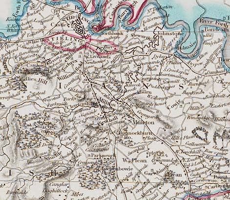
University of Glasgow

UNIVERSITY of GLASGOW

 
Part of the Library and University Services

Please note that these pages are from our old (pre-2010) website; the presentation of these pages may now appear outdated and may not always comply with current accessibility guidelines.
Introduction
16th Century
17th Century
18th Century
19th Century

Maps for a Small Country

An exhibition of historical maps and atlases of Scotland,
held in Glasgow University Library

19th Century


DENHOLM, James.
A Plan of the City of Glasgow from a survey in 1804. In The History of the City of Glasgow and Suburbs. 3rd edition. Glasgow, 1804.
Engraved by R. Scott.
175 x 290mm. Scale 1'':1000 feet.
Bh11 - d.13


Detail of plan showing York Street
riding school on the left.
Click on image to enlarge.


Denholm's history and guide first appeared as a pocket book in 1797 with a map from a survey done that year. This plan is clearly from the same plate, now slightly worn, with some minor changes in the St. Enoch's Square area, the addition of York Street and its riding school, and the introduction of Hutchesons Hospital and the New Barony Church to the table of references. By this date, the guide had expanded to some 600 pages and further editions were to appear in
1812, 1818 and 1826.
 
  FLEMING, Peter. Map of the City of Glasgow and Suburbs surveyed and corrected till January 1807. Glasgow, 1807.
Engraved by R. Scott.
1185 x 1695mm. Scale 1":192 feet.
Mu24 - y.21

Detail of plan including the
royal boundary in blue.
Click on image to enlarge.
This map, first advertised as published in the Glasgow Herald for 21st August 1807 at a cost of two guineas coloured and mounted in rollers or £2-10-0d varnished, and originally issued on six sheets, follows on in sequence from the surveys of McArthur and Barry of the previous century. Already the city's spread to both the west and east is quite marked and many designs for new streets are also shown. There is much detail of various industries developing in and around the city and many buildings are named or their owners shown. Fleming continues to indicate the royalty boundary with each marker stone sited.
  Fleming was employed by the city to draw street maps for submission to Parliament and, in October 1807, he was further supported by the purchase of a copy of this plan for each of the ministers of the city. The 1803 Glasgow directory lists Fleming at William Kyle's. Kyle was one of Glasgow's most important surveyors and it is possible that Fleming either trained or was in association with him. Robert Scott, an Edinburgh engraver, had previously prepared Denholm's plan of the city in 1797 and the one illustrating McFeat's 1801 Directory. Fleming's plan was re-issued in 1808 as a single sheet and, again, in 1820.
  BROWN, Thomas. A New and Accurate Map of Selkirkshire from the latest surveys. In Atlas of Scotland being a New Set of County Maps. Edinburgh 1807. Plate 6.
330 x 280mm. Scale 1'':2.4mIs.
Mu2 -x.11

Detail of map showing area
around Selkirk.
Click on image to enlarge.
  Brown's atlas began publication in 1802 and the final sheets were issued five years later. The Selkirk sheet is one of five with an 1802 watermark. It is possible that the maps may have been available singly. In comparison with Armstrong's 1777 atlas, there is far more detail of settlement, road, river and hill features, the latter now being decided by hachures. Brown was in business as a bookseller and publisher and the county sheets are most likely based on one of the several sheet maps of Scotland issued about this time - certainly there are closer similarities with Stockdale than Cary or Ainslie - and it should be noted that St. Mary's Loch is mapped here whereas it was omitted from Brown's 1795 copy of Ainslie.
  ROBERTSON, James. Map of the Soil of lnvernesshire. In General View of the Agriculture in the County of Inverness, London, 1808.
Engraved by S.J.Neele.
285 x 365mm. Scale 1'':6.5mls.            
Mu2 - c.35


In the final decade of the eighteenth century an agricultural survey of each county was commissioned by the Board of Agriculture, and those published between 1805 and 1816 contain a fascinating amount of detail on farming practice, planting, transport, housing conditions and the general picture of the country. Of the many county volumes, less than half contain small county maps either of soils or a more general nature. This map gives a quite cursory view with only six soil categories. However, the settlement, road and topographical detail is superior to any atlas map of the county to that date and appears to be based on John Stockdale's 12 sheet map of Scotland of 1806 which Neele had also engraved. The volume also contains a plan, by Telford and Downie, of the
intended Caledonian Canal.


Detail of map showing soil types in part of Invernesshire.
Click on image to enlarge.

 
Detail of plan showing surveyed fields.
Click on image to enlarge.
AINSLIE, John. Harestanes Farm surveyed with the Plain Table by a new method. In Comprehensive Treatise on Land Surveying. Edinburgh, 1812. Plate 7, no.2.
160 x 185mm. Scale 1”:7 chains.
DL.7.4  

Ainslie was arguably the outstanding Scots cartographer of the late eighteenth and early nineteenth centuries, with a large number of maps of the finest quality to his name. He trained in England under Thomas Jefferys, Geographer to George III but returned to Scotland in 1771. Town plans, county and estate surveys, including the remarkable volumes of plans for the Eglinton estate, and maps of Scotland followed - all displaying his versatility and attention to detail. In 1802, he published The Gentleman and Farmer's Pocket Companion and Assistant as a manual for surveyors. Its favourable reception encouraged this comprehensive guide to all the aspects of land surveying, in both theory and practice, covering private properties and county surveys, the use of various instruments, delineating and reducing plans and the use of colours in adorning maps. His experience, practical advice and observation is imparted to the novice throughout the work. This plate shows the farm of Harestanes surveyed by plain table, with the field book on the opposite page.

Bibliography: R.S.G.S. op cit pp120-1, 125-6.


Detail of map showing part of
Old Monkland.
Click on image to enlarge.
FORREST, Wlllam. The County of Lanark from actual survey. Edinburgh, 1816.
Engraved by L.& G. Menzies.
1840 x 1535mm. Scale 1'':0.67m
Mu2 - d.22

Forrest produced this map, originally issued in eight sheets, from a survey of 1813 and it is, undoubtedly, the most detailed and accurate coverage of the county prior to the work of the Ordnance Survey. The quality of draughtsmanship reflects the high standard of precision in distance and orientation reached by Scottish surveyors at this time. John Thomson, himself an important map publisher, describes Forrest's surveys as ''of the first rate".

Settlement is well depicted (e.g. in Libberton parish, 76 locations are marked, in Old Monkland 160) and the growing industrialisation of the county is seen in the mapping of the Monkland canal and several coal mines.

It is most likely that Forrest followed the contemporary pattern of basing the map on estate surveys - certainly a beautiful plan of the estates of Drumpellier and Coats, drawn by him, is held In Airdrie District Library - and it must have met with some success, for a second issue appeared in 1818. From a pasted catalogue slip, it appears that David Murray purchased this map for the very reasonable price of 10/6d - another glimpse of the perceived value of a map.

  Lizars, W. and D.(Engravers). A Map of Renfrewshire. In CRAWFURD, George A General Description of the Shire of Renfrew, continued by George Robertson. Paisley, 1818.
368 x 480mm. Scale 1":1.6mls.
Mu25 - y.24

Detail of map showing Glasgow
and surrounding area.
Click on image to enlarge.
  William and Daniel Lizars were Edinburgh engravers whose partnership terminated in 1819, William continuing in the business and producing a series of plans of Edinburgh for the annual directories, several county geological maps and the maps which illustrate the volumes of the New Statistical Account of Scotland. In comparison with the map which accompanies the Renfrew volume of the NSA of 1845, this depiction gives much more detail of settlement, roads, estates and their owners, mosses and rivers. Parishes are indicated and one interesting unnamed feature is the heavy line running south-west via Castle Semple Loch - possibly the line of the canal to Ardrossan. In his preface, Robertson acknowledges his reliance on John Ainslie's map of the county, published in 1800, with regards to localities and we can assume that this is based on that earlier depiction.
 

MACCULLOCH, John. Arran, with Lamlash and Pladda. In A Description of the Western Islands of Scotland. Vol.3. London, 1819. Opposite p83.
Engraved by Josiah Cross.
235 x 175mm. Scale 1'':2.13 mls.
Mu11-a.1-3

Born in Guernsey in 1773, MacCulloch studied medicine at Edinburgh where he attended the Natural History class. During his time as Chemist to the Ordnance, a post held from 1806, he also acted as Geologist to the Trigonometrical Survey - in fact, the "earliest government-sponsored geological surveyor in Britain". This afforded him great opportunities for study and many of his reports appeared in the Transactions of the Geological Society of London. His Description of the Western Islands is regarded as a classic work and is illustrated by his own maps. The outline of the island bears a close resemblance to that on William Smith's map of 1815 but textual comments suggest that MacCulloch was dissatisfied with both the accuracy and scale of existing map coverage. The atlas was the product of eight summers' field work and the maps were the first to illustrate Scottish geological features by means of strike lines and dip arrows, more lithologically and structurally detailed than their precursors.

Bibliography: BOUD R.C. ''The early geological maps of the isle of Arran, 1807-1858'' Canadian cartographer vol. 12 1975, pp179-193. CUMMING, D.A. 'Geological maps in preparation: John MacCulloch on western islands'' Archives of Natural History vol. 10, 1981 , pp255-271.


Detail of map showing soil types on the Isle of Arran.
Click on image to enlarge.
WOOD, John. Plan of the Cities of Aberdeen. In Town Atlas of Scotland. Edinburgh, 1828.
Engraved by T. Clerk.
640 x 490mm. Scale c1'':630 feet.
Mu2 - x.14

Detail of plan showing 'Old Aberdeen'
Click on image to enlarge.
The publication of John Wood's Town Atlas is a distinct landmark in the history of urban cartography for with it came the first systematic depiction of many Scots towns. Forty eight plans appeared in the first issue and were accompanied by a Descriptive Account of the Principal Towns - the result of ten years' labour. Some surveyed towns do not appear in this issue and not all the delineations are from Wood's own work - for Leith, ''Lothian's Plan of the town of Leith" of 1826 is included. The plans could be purchased separately in the local towns and from Thomas Brown, the Edinburgh bookseller. This illustration of Aberdeen is ''continued from Mr. Smith's survey made in 1809'' and refers to John Smith's plan published in 1810.

Bibliography: ''Wood's town atlas'' British Museum Quarterly, vol.27, 1963, pp5960.
JOHNSON, William. Stirlingshire. In THOMSON, John, The Atlas of Scotland. Edinburgh, 1832. Plate 14.
Engraved by Sidney Hall.
515 x 680mm. Scale 1'':1.67mls        
Sp.Coll e33


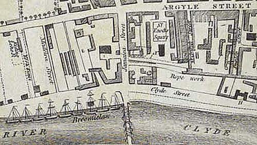
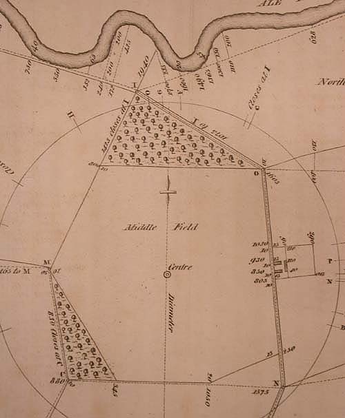
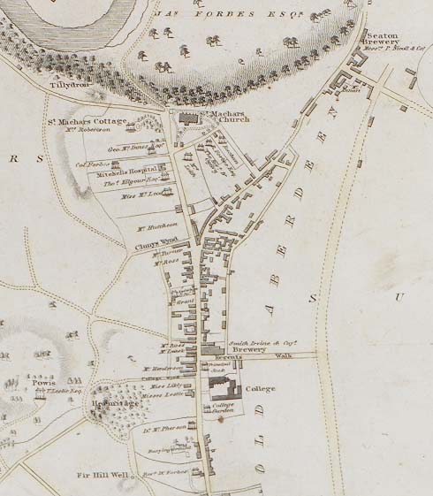
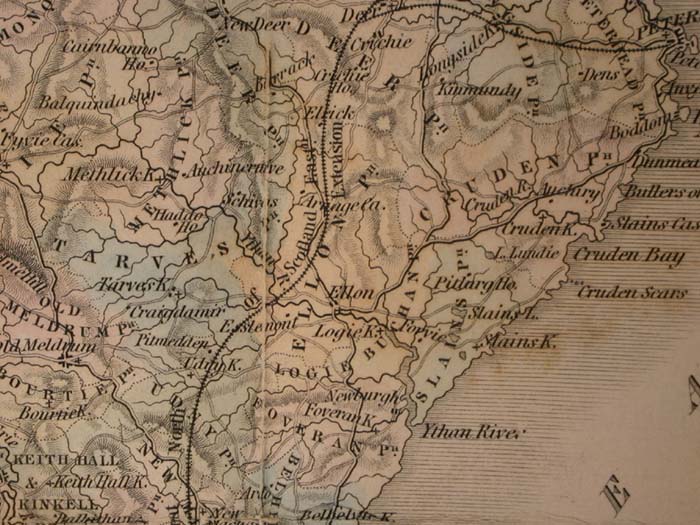
Detail of map showing area around Stirling.
Click on image to enlarge.

Thomson worked in Edinburgh for over twenty years as an atlas publisher but the cost of production of this Atlas of Scotland ruined him, despite an initial subscription list exceeding 1200. In April, 1830, he applied for sequestration as a bankrupt and the volume was delayed in publication until 1832, Thomson being aided by financial support from his friends. The production of the sheets was spread over the period 1820 to 1830 and the loose sheets were sold as they became available. In about 1838, the plates were acquired by W.&A.K. Johnston who re-issued the maps separately under their name.

Without doubt this is a most ambitious work and recalls the artistry of Blaeu's cartography. For most counties, existing county surveys were used as a base, new maps being drawn from them and revised by surveyors and local authorities. Engravers in both Edinburgh and London were employed. This map of Stirlingshire is based on the four-sheet survey of John Grassom of 1817, redrawn by William Johnson an Edinburgh land surveyor and attested by, among others, Grassom himself. As with the other county sheets, a plan of the county town is also included.

Bibliography: R.S.G.S. op cit pp129-131.


Detail of map listing the different soil types in Sutherland.
Click on image to enlarge.
CUNNINGHAM, Robert James Hay. Geognostical Map of Sutherland.
In ''Geognostical Account of the County of Sutherland''
Prize Essays and
Transactions of the Highland and Agricultural Society of Scotland, vol 13, 1841, pp73-114.
Engraved by W.H.Lizars.
Edinburgh, 1839.
300 x 355mm. Scale 1'':5mls
Agriculture Periodicals P6000

Cunningham was a geologist of precocious talent whose careful mapping techniques were possibly learnt from Robert Jameson, Professor of Natural History at the University of Edinburgh. His reputation was established by his work on the geology of the Lothians but, tragically, his career lasted for less than ten years.

During the early decades of the nineteenth century, the development of geological mapping in Scotland was supported by several scientific societies and, more notably, by the Highland and Agricultural Society of Scotland. From 1837 onwards a number of county and district surveys were published as a direct result of its premium for the production of such maps, in the interest of agriculture. Cunningham gained a price of fifty sovereigns for this account - one of four price competitions he won. His map which first appeared in 1839 to accompany his paper, On the Geognosy of Sutherlandshire was based on the county map of 1833 by Burnett and Scott.

Bibliography: WATERSTON, C.D. ''Robert James Hay Cunningham (1815-1842)'' Transactions of the Edinburgh Geological Society, vol.17, 1957-59, pp260-272.

 
Detail of map showing the central districts of Glasgow.
Click on image to enlarge.

 
PERRY, Robert. Glasgow and Suburbs. In Facts and Observations of the Sanitory State of Glasgow during the last year. Glasgow, 1844.
255 x 415mm   
Mu26-a.29

The development of thematic mapping of such major social issues as health and crime was particularly notable in the towns and cities of Victorian Britain. Maps were often used to illustrate medical reports, the techniques becoming more sophisticated through time. Perry was Senior Physician to Glasgow Royal Infirmary and, in this map, he traces the course of an influenza or relapsing fever epidemic which affected the city in 1843. Using reports collected from the local surgeons he ''laid down and numbered the different districts upon a map of the city...marking with a darker shade those parts where the epidemic was most particularly prevalent, which shows that those places most densely inhabited, by the poorest of the people, have suffered most severely". Both the report and map served another humane purpose; they were published by the Royal Asylum for Lunatics at Gartnavel and an accompanying note reads: "in order to aid the laudable design of Dr. Hutchison in exercising the mental and bodily faculties of the inmates of the Lunatic Asylum, the Printing of this Paper, the Colouring the Maps, &c, is wholly the work of the inmates”.

  BLACKWOOD, Wllliam. Aberdeen Shire. Blackwood's County Maps. Edinburgh, c 1853.
Engraved by W.H.Lizars
180 x 240mm. Scale 1":8.5mls.            
Case Maps C18:10101

Blackwood was responsible for printing the Statistical Account of the parishes of Scotland, begun in 1834. The county volumes contained engraved maps which were collected into an atlas published in 1838 or separately issued "in a neat case for the pocket. price ls. each". W.H.Lizars updated these, particularly in the depiction of the road network, in 1839 and the maps re-appeared in the issued set of the New Statistical Account (NSA) in 1845. A second edition of the atlas came out in 1853, with railways indicated. This copy would appear to date from this later period.

Being related to the NSA, the map identifies each parish and, although the scale prevents much place-name detail, there is a clear preference for locating parish churches. The road pattern has been improved with many more routes indicated than in 1845.


Detail of map showing part of the coast of
Aberdeen Shire.
Click on image to enlarge.

  STEVENSON, Robert Louis. The Map of Treasure Island reproduced from the original.
Frontispiece to Treasure Island. London, 1883.
c160 x 90mm. Scale 1":3.43mls        
Case English MS780 1906-G Vol 5


Detail of map showing Treasure Island.
Click on image to enlarge.

Possibly the most famous map in all English literature, Captain Flint's map of Treasure Island given to Billy Bones and used by Jim Hawkins, Squire Trelawney and Dr. Livesey in their search for the horde. The map is based on an original drawn by Stevenson and Fanny Osbourne's son, Lloyd, and the novel was commenced while staying in Braemar between August and September 1881. Inspired by Lloyd's excitement about the map, and encouraged by his father who was visiting them, the author set about inventing a story to fit the map, based on his reading, experience and the scenery of the California coast. It was serialised in Young Folks, a boys' magazine between October 1881 and January 1882 and, thereafter, published in book form in November 1883.