

What’s Under Our Feet: Exploring Glasgow’s Sub-surface
2 May – 31 July 2014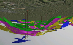
Hunterian Museum
Admission free
The digital model allows users to easily explore and visualise these multiple sources of information. This is probably the most complex subsurface model created for any city in the world. See it here.
This information is vital to planners, developers and construction projects, and the CUSP models have underpinned much of the Commonwealth Games developments in the east end of Glasgow, and the wider Clyde Gateway project.
CUSP and the University of Glasgow
CUSP has been designed to grow and develop as new data sources are found. The University of Glasgow archives include extensive records about the subsurface in the west end of Glasgow which have not yet been digitized. This is being explored at the moment. CUSP provides a standard way of presenting the data and makes the information infinitely reusable.
The Exhibition
The exhibition presents rock specimens representative of the geology of the Clyde Valley and the rocks under the University; archival maps, papers and photographs on the subsurface of the University including information on the mine under the Joseph Black (Chemistry) building. Addressing the industrial/social aspects of the underlying geology, bricks and pottery made from local clays are on show and intriguingly, a 16th century miner’s tobacco pipe recovered from a Glasgow borehole.
Why does the underground matter?
Here are some ideas to ponder...
- Finding and exploiting mineral resources: coal, shale gas (and in past, iron, building stone, clay, cement, lime).
- How solid/stable is the ground for building on?
- How can we reduce subsidence in an area?
- How will groundwater move?
- Is the soil safe to grow vegetables?
- Recreating past landscapes: looking at Carboniferous coal swamps, rivers, lagoons and seas in 3D.
Other links
Department of Geographical and Earth Sciences
University of Glasgow Archives
Image: A still from the 3D visualisation of CUSP’s ‘modelling’ of some of the rock layers beneath Glasgow’s East End. The black vertical lines are mine shafts descending beneath the ground surface and the short lines extending off the shafts are the mine working levels.
Events Programme
May
Insight Talk
Tuesday 6 May 2014
1.00pm – 1.15pm
Hunterian Museum
On the CUSP - a new way of looking at Glasgow's old dirt and rocks
Professor Paul Bishop, Geographical and Earth Sciences, University of Glasgow
Lunchtime Learning - Friday Science Demo/Talk
Friday 16 May 2014
1.00pm – 1.30pm
Hunterian Museum
Topic and speaker to be confirmed
Insight Talk
Tuesday 27 May 2014
1.00pm – 1.15pm
Hunterian Museum
Glacial History of Glasgow
Dr Derek Fabel, Geographical and Earth Sciences, University of Glasgow
June
Part of the Glasgow Science Festival (5 - 15 June 2014) and Universities Week 2014 (9 - 15 June 2014)
 Mapping the Campus
Wednesday 11 June 2014
12.00pm – 2.00pm
Sunday 15 June 2014
11.00am - 12.00pm, 1.00pm - 2.00pm and 2.00pm - 3.00pm
Hunterian Museum*
Mapping the rocks under our feet. Try your hand at geological mapping with the assistance of some of our student experts. Also see the surface traces of some of the underground secrets of the campus. This will take about an hour and will involve walking on pavements and paths around the University. 16 + age group. *Start at the Hunterian Museum, then go around the University Campus. Free but booking required. Click here to book.
 Mapping the Campus for Kids
Sunday 15 June 2014
11.00am – 12.00pm, 1.00pm - 2.00pm and 2.00pm - 3.00pm
Hunterian Museum*
The secret history of buildings, roads and pavements. A fun discovery trail around the University looking at how we use underground materials to build stuff, and how the underground secrets of the University can be seen around the campus. Suitable for 8 + age group. Free drop-in activity. Takes about an hour. *Start at the Hunterian Museum, then go around the University Campus.
July
Insight Talk
Tuesday 8 July 2014
1.00pm – 1.15pm
Hunterian Museum
Bricks, pots, tropical weathering and glaciers: the geology and uses of clay in and around Glasgow
Dr John Faithfull, The Hunterian
Lunchtime Learning - Friday Science Demo/Talk
Friday 25 July 2014
1.00pm – 1.30pm
Hunterian Museum
The story of a clay tobacco pipe
Dennis Gallagher, Society for Clay Pipe Research
Around 1650, a miner dropped his clay pipe deep underground in a Glasgow coalmine. Over 300 years later, the pipe miraculously popped out at the surface among drill core recovered from a borehole. Clay pipe fragments are very common in industrial waste, and provide fascinating clues about the past.